Khujner night lights from space
Night Light of Khujner (Madhya Pradesh) from space (India) Src. Average luminocity for 10x10km area is 12.6905% and for 50x50km: 5.7932%.
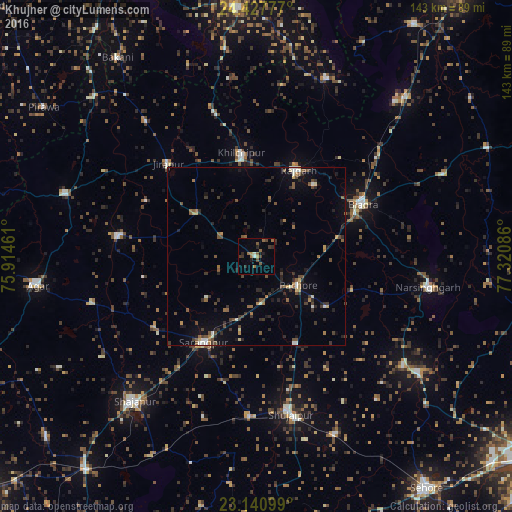
Analysis of Khujner night lights 2016
Square area 10x10 km:
 0.6%
0.6%90-99
0.99%80-89
0%70-79
1.39%60-69
3.77%50-59
3.77%40-49
2.38%30-39
2.18%20-29
3.57%10-19
1.98%0-9
79.37%Square area 50x50 km:
0.28%90-99
0.53%80-89
0.36%70-79
0.42%60-69
0.94%50-59
1.18%40-49
1.14%30-39
1.46%20-29
1.76%10-19
2.27%0-9
89.66%Clear (daylight) street map image can be seen on geolist.org.
Map coordinates:
24° 25' 40" North, 75° 54' 52.6" East
23° 47' 9.5" North, 76° 37' 3.8" East
23° 8' 27.6" North, 77° 19' 15.1" East
Some cities around Khujner sort by population:
• Shujālpur
43.2 km =26.8 mi,  167°
167°
• Biaora
33.3 km =20.7 mi,  63°
63°
• Sārangpur
28.5 km =17.7 mi,  211°
211°
• Rājgarh
27.3 km =17 mi,  25°
25°
• Khilchipur
28.5 km =17.7 mi,  351°
351°
• Akodia
45.2 km =28.1 mi,  182°
182°
• Talen
26.6 km =16.5 mi,  154°
154°
• Māchalpur
48.8 km =30.3 mi,  321°
321°
1266632 (p: 9,950)
Sources (retrieved 2019-11-25):
» Earth at Night: Flat Maps 2012, 2016