Chākuliā night lights from space
Night Light of Chākuliā (Jharkhand) from space (India) Src. Average luminocity for 10x10km area is 7.7708% and for 50x50km: 5.1033%.
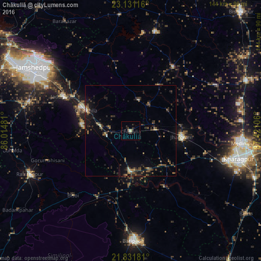
Analysis of Chākuliā night lights 2016
Square area 10x10 km:
 0.38%
0.38%90-99
1.14%80-89
0.95%70-79
0.76%60-69
0.57%50-59
0%40-49
2.27%30-39
3.6%20-29
3.03%10-19
1.7%0-9
85.61%Square area 50x50 km:
0.08%90-99
0.35%80-89
0.44%70-79
0.31%60-69
0.71%50-59
0.87%40-49
1.33%30-39
1.54%20-29
2%10-19
3.7%0-9
88.67%Clear (daylight) street map image can be seen on geolist.org.
Map coordinates:
23° 7' 52.2" North, 86° 0' 53.3" East
22° 28' 58.8" North, 86° 43' 4.5" East
21° 49' 54.5" North, 87° 25' 15.8" East
Some cities around Chākuliā sort by population:
• Kharagpur
64.4 km =40 mi,  104°
104°
• Medinīpur
62.5 km =38.8 mi, 96°
• Jhārgrām
28.6 km =17.8 mi, 96°
• Jugsālai
63.8 km =39.6 mi,  300°
300°
• Ghātsīla
27.2 km =16.9 mi,  294°
294°
• Mushābani
27 km =16.8 mi,  276°
276°
• Kuchaiburi
60.9 km =37.8 mi,  246°
246°
• Khātra
56.6 km =35.2 mi,  14°
14°
1274881 (p: 14,952)
Sources (retrieved 2019-11-25):
» Earth at Night: Flat Maps 2012, 2016