Bāgli night lights from space
Night Light of Bāgli (Madhya Pradesh) from space (India) Src. Average luminocity for 10x10km area is 9.7996% and for 50x50km: 3.451%.
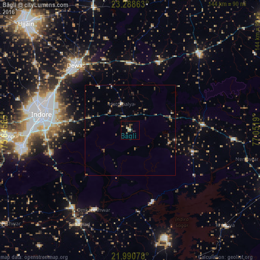
Analysis of Bāgli night lights 2016
Square area 10x10 km:
100  0.4%
0.4%
90-99 1.19%
80-89 1.59%
70-79 0.6%
60-69 0.99%
50-59 1.59%
40-49 3.97%
30-39 1.59%
20-29 1.59%
10-19 0%
0-9 86.51%
0.4%90-99
1.19%80-89
1.59%70-79
0.6%60-69
0.99%50-59
1.59%40-49
3.97%30-39
1.59%20-29
1.59%10-19
0%0-9
86.51%Square area 50x50 km:
100 0.06%
90-99 0.3%
80-89 0.36%
70-79 0.32%
60-69 0.43%
50-59 0.7%
40-49 0.93%
30-39 0.98%
20-29 1.09%
10-19 0.84%
0-9 93.96%
0.06%90-99
0.3%80-89
0.36%70-79
0.32%60-69
0.43%50-59
0.7%40-49
0.93%30-39
0.98%20-29
1.09%10-19
0.84%0-9
93.96%Clear (daylight) street map image can be seen on geolist.org.
Map coordinates:
23° 17' 19.1" North, 75° 38' 44.3" East
22° 38' 28.5" North, 76° 20' 55.6" East
21° 59' 26.8" North, 77° 3' 6.8" East
Some cities around Bāgli sort by population:
• Indore
53.6 km =33.3 mi,  279°
279°
• Punāsa
45.4 km =28.2 mi,  174°
174°
• Dewas
47 km =29.2 mi,  320°
320°
• Ashta
56.7 km =35.2 mi,  42°
42°
• Kannod
40.5 km =25.2 mi,  85°
85°
• Satwās
36.4 km =22.6 mi,  108°
108°
• Iklehra
56.4 km =35 mi,  4°
4°
• Iāwar
43.8 km =27.2 mi,  20°
20°
1277874 (p: 10,764)
Sources (retrieved 2019-11-25):
» Earth at Night: Flat Maps 2012, 2016