Kadaura night lights from space
Night Light of Kadaura (Uttar Pradesh) from space (India) Src. Average luminocity for 10x10km area is 3.7381% and for 50x50km: 2.0886%.
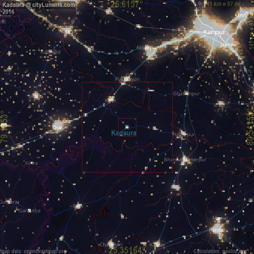
Analysis of Kadaura night lights 2016
Square area 10x10 km:
 0.99%
0.99%90-99
0.6%80-89
0%70-79
0%60-69
0%50-59
0.79%40-49
1.19%30-39
1.19%20-29
1.19%10-19
0.4%0-9
93.65%Square area 50x50 km:
0.19%90-99
0.4%80-89
0.18%70-79
0.08%60-69
0.19%50-59
0.52%40-49
0.3%30-39
0.34%20-29
0.43%10-19
0.48%0-9
96.88%Clear (daylight) street map image can be seen on geolist.org.
Map coordinates:
26° 36' 56.5" North, 79° 8' 7.1" East
25° 59' 7.3" North, 79° 50' 18.3" East
25° 21' 5.9" North, 80° 32' 29.6" East
Some cities around Kadaura sort by population:
• Orai
38.5 km =23.9 mi,  270°
270°
• Kālpi
18 km =11.2 mi,  324°
324°
• Ghātampur
37.8 km =23.5 mi,  60°
60°
• Hamīrpur
31.2 km =19.4 mi,  96°
96°
• Pukhrāyān
26.5 km =16.5 mi,  359°
359°
• Kurāra
15.1 km =9.4 mi,  92°
92°
• Sarīla
28.4 km =17.6 mi,  214°
214°
• Gohānd
43.3 km =26.9 mi,  222°
222°
1268686 (p: 13,784)
Sources (retrieved 2019-11-25):
» Earth at Night: Flat Maps 2012, 2016