Hosakote night lights from space
Night Light of Hosakote (Karnataka) from space (India) Src. Average luminocity for 10x10km area is 4.3983% and for 50x50km: 3.373%.
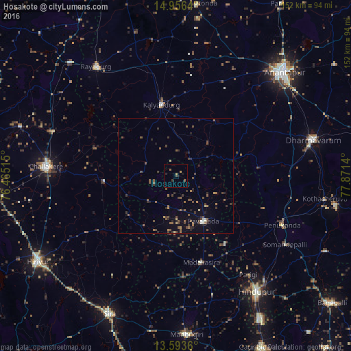
Analysis of Hosakote night lights 2016
Square area 10x10 km:
 0%
0%90-99
0%80-89
0%70-79
1.73%60-69
0.87%50-59
0.87%40-49
0.87%30-39
0.87%20-29
0.87%10-19
1.73%0-9
92.21%Square area 50x50 km:
0.03%90-99
0.19%80-89
0.23%70-79
0.2%60-69
0.62%50-59
1.05%40-49
0.96%30-39
0.78%20-29
0.98%10-19
0.85%0-9
94.11%Clear (daylight) street map image can be seen on geolist.org.
Map coordinates:
14° 57' 23" North, 76° 27' 54.5" East
14° 16' 33.7" North, 77° 10' 5.8" East
13° 35' 37" North, 77° 52' 17" East
Some cities around Hosakote sort by population:
• Anantapur
65.1 km =40.5 mi,  46°
46°
• Hindupur
60.8 km =37.8 mi,  145°
145°
• Dharmavaram
61.4 km =38.2 mi,  75°
75°
• Rāyadrug
58.1 km =36.1 mi,  324°
324°
• Challakere
55.9 km =34.7 mi,  274°
274°
• Pāvugada
23 km =14.3 mi, 148°
• Kalyandurg
30.7 km =19.1 mi,  347°
347°
• Penukonda
50.7 km =31.5 mi,  115°
115°
1269947 (p: 11,692)
Sources (retrieved 2019-11-25):
» Earth at Night: Flat Maps 2012, 2016