Harsūd night lights from space
Night Light of Harsūd (Madhya Pradesh) from space (India) Src. Average luminocity for 10x10km area is 1.8671% and for 50x50km: 4.6416%.
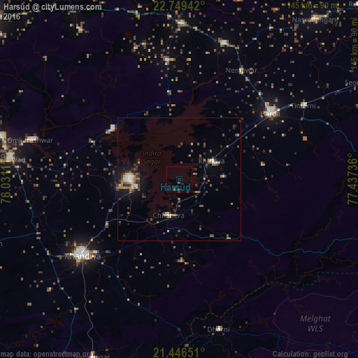
Analysis of Harsūd night lights 2016
Square area 10x10 km:
 0%
0%90-99
0%80-89
0%70-79
0%60-69
0.79%50-59
0%40-49
1.59%30-39
0.79%20-29
0%10-19
0%0-9
96.83%Square area 50x50 km:
0.31%90-99
0.49%80-89
0.43%70-79
0.36%60-69
0.83%50-59
0.87%40-49
0.94%30-39
1.18%20-29
1.16%10-19
2.72%0-9
90.71%Clear (daylight) street map image can be seen on geolist.org.
Map coordinates:
22° 44' 57.9" North, 76° 1' 52" East
22° 5' 58.1" North, 76° 44' 3.2" East
21° 26' 47.4" North, 77° 26' 14.5" East
Some cities around Harsūd sort by population:
• Punāsa
38.2 km =23.7 mi,  293°
293°
• Khandwa
50 km =31.1 mi,  232°
232°
• Harda Khās
46.1 km =28.6 mi,  53°
53°
• Khātegaon
58.2 km =36.2 mi,  18°
18°
• Khirkiyān
15.1 km =9.4 mi,  60°
60°
• Kannod
63.2 km =39.3 mi,  0°
0°
• Satwās
48.8 km =30.3 mi,  353°
353°
• Mundi
25.1 km =15.6 mi,  261°
261°
1270271 (p: 16,736)
Sources (retrieved 2019-11-25):
» Earth at Night: Flat Maps 2012, 2016