Mundi night lights from space
Night Light of Mundi (Madhya Pradesh) from space (India) Src. Average luminocity for 10x10km area is 26.4762% and for 50x50km: 5.2824%.
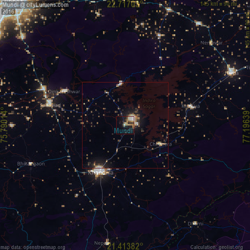
Analysis of Mundi night lights 2016
Square area 10x10 km:
 3.97%
3.97%90-99
3.57%80-89
3.57%70-79
4.56%60-69
4.37%50-59
2.18%40-49
1.98%30-39
3.97%20-29
6.75%10-19
22.42%0-9
42.66%Square area 50x50 km:
0.29%90-99
0.7%80-89
0.54%70-79
0.38%60-69
0.71%50-59
0.79%40-49
0.94%30-39
1.55%20-29
1.52%10-19
4.34%0-9
88.24%Clear (daylight) street map image can be seen on geolist.org.
Map coordinates:
22° 43' 1.3" North, 75° 47' 24.5" East
22° 4' 0.9" North, 76° 29' 35.7" East
21° 24' 49.8" North, 77° 11' 47" East
Some cities around Mundi sort by population:
• Punāsa
21.3 km =13.2 mi,  331°
331°
• Khandwa
30.7 km =19.1 mi,  208°
208°
• Sanāwad
45.2 km =28.1 mi,  285°
285°
• Khirkiyān
39.5 km =24.5 mi,  73°
73°
• Harsūd
25.1 km =15.6 mi,  81°
81°
• Bhikangaon
58.9 km =36.6 mi,  247°
247°
• Satwās
55.8 km =34.7 mi,  20°
20°
• Pandhāna
49.5 km =30.8 mi, 214°
1262504 (p: 11,409)
Sources (retrieved 2019-11-25):
» Earth at Night: Flat Maps 2012, 2016