Alāwalpur night lights from space
Night Light of Alāwalpur (Punjab) from space (India) Src. Average luminocity for 10x10km area is 23.6818% and for 50x50km: 23.5995%.
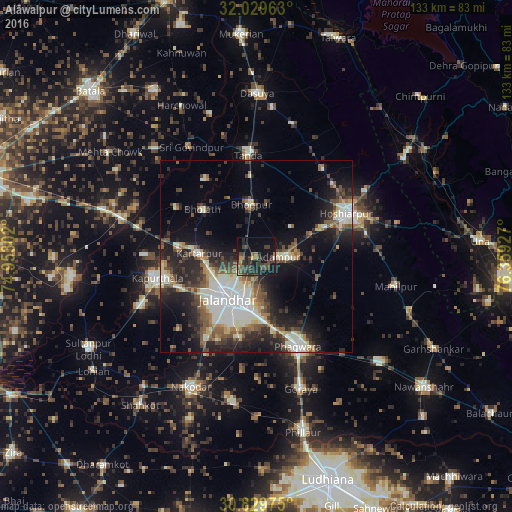
Analysis of Alāwalpur night lights 2016
Square area 10x10 km:
 0%
0%90-99
0.87%80-89
1.57%70-79
1.75%60-69
2.45%50-59
4.02%40-49
9.62%30-39
13.11%20-29
8.92%10-19
30.59%0-9
27.1%Square area 50x50 km:
3.43%90-99
5.56%80-89
2.09%70-79
1.76%60-69
2.32%50-59
3.67%40-49
3.95%30-39
4.31%20-29
7.86%10-19
12.87%0-9
52.18%Clear (daylight) street map image can be seen on geolist.org.
Map coordinates:
32° 1' 46.7" North, 74° 57' 10.9" East
31° 25' 53.8" North, 75° 39' 22.1" East
30° 49' 47.1" North, 76° 21' 33.4" East
Some cities around Alāwalpur sort by population:
• Jalandhar
13.9 km =8.6 mi,  211°
211°
• Phagwāra
25.6 km =15.9 mi,  154°
154°
• Kapūrthala
26.7 km =16.6 mi,  257°
257°
• Kartārpur
15 km =9.3 mi,  274°
274°
• Bhogpur
13.7 km =8.5 mi,  354°
354°
• Adampur
5.6 km =3.5 mi,  89°
89°
• Bhulath Gharbi
18.7 km =11.6 mi,  311°
311°
• Begowāl
23.7 km =14.7 mi,  327°
327°
1279050 (p: 7,410)
Sources (retrieved 2019-11-25):
» Earth at Night: Flat Maps 2012, 2016