Dalsingh Sarai night lights from space
Night Light of Dalsingh Sarai (Bihar) from space (India) Src. Average luminocity for 10x10km area is 50.3258% and for 50x50km: 34.355%.
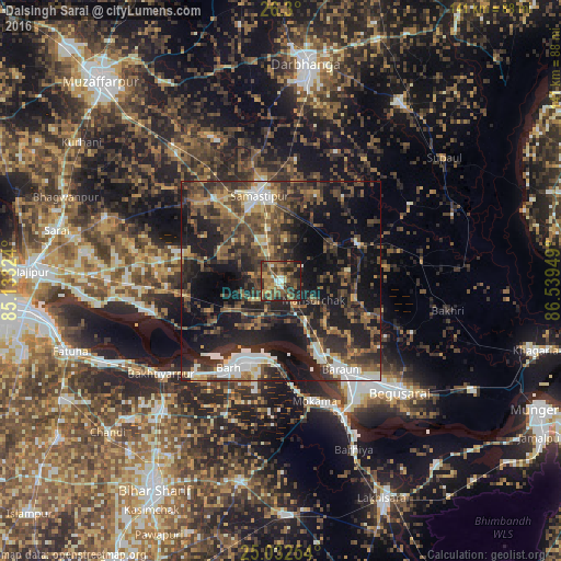

Analysis of Dalsingh Sarai night lights 2016
Square area 10x10 km:
 1.89%
1.89%90-99
5.3%80-89
4.55%70-79
7.77%60-69
15.34%50-59
11.93%40-49
17.99%30-39
15.34%20-29
13.64%10-19
6.25%0-9
0%Square area 50x50 km:
3.52%90-99
4.29%80-89
2.51%70-79
3.57%60-69
4.46%50-59
7.13%40-49
9.14%30-39
9.92%20-29
13.46%10-19
24.39%0-9
17.6%Clear (daylight) street map image can be seen on geolist.org.
Map coordinates:
26° 18' 0" North, 85° 7' 59.7" East
25° 40' 4.6" North, 85° 50' 10.9" East
25° 1' 57.1" North, 86° 32' 22.2" East
Some cities around Dalsingh Sarai sort by population:
• Bāruni
25.2 km =15.7 mi,  148°
148°
• Samāstipur
22.3 km =13.9 mi,  345°
345°
• Mokameh
31.4 km =19.5 mi,  164°
164°
• Bārh
24.2 km =15 mi,  211°
211°
• Teghra
22.3 km =13.9 mi, 152°
• Bakhtiyārpur
38.2 km =23.7 mi,  233°
233°
• Rusera
21.2 km =13.2 mi,  63°
63°
• Mohiuddinnagar
19.7 km =12.2 mi,  237°
237°
1273628 (p: 21,611)
Sources (retrieved 2019-11-25):
» Earth at Night: Flat Maps 2012, 2016