Dalkola night lights from space
Night Light of Dalkola (West Bengal) from space (India) Src. Average luminocity for 10x10km area is 27.3958% and for 50x50km: 7.7684%.
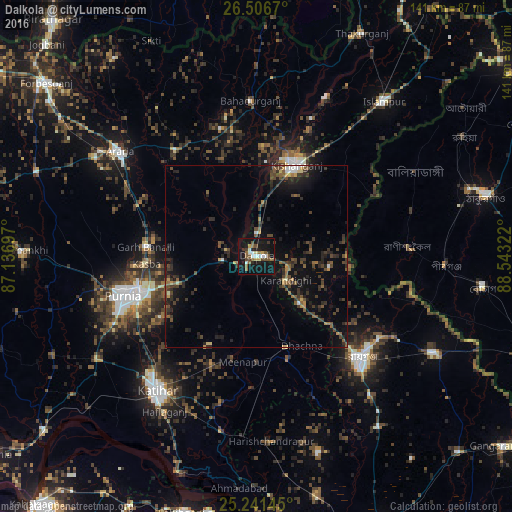
Analysis of Dalkola night lights 2016
Square area 10x10 km:
 3.6%
3.6%90-99
3.22%80-89
1.52%70-79
2.27%60-69
4.36%50-59
6.44%40-49
4.36%30-39
3.03%20-29
4.92%10-19
45.27%0-9
21.02%Square area 50x50 km:
0.39%90-99
0.44%80-89
0.43%70-79
0.69%60-69
0.66%50-59
1.61%40-49
2.15%30-39
2.27%20-29
2.81%10-19
7.38%0-9
81.17%Clear (daylight) street map image can be seen on geolist.org.
Map coordinates:
26° 30' 24.1" North, 87° 8' 13.1" East
25° 52' 32.8" North, 87° 50' 24.3" East
25° 14' 29.2" North, 88° 32' 35.6" East
Some cities around Dalkola sort by population:
• Purnia
38.2 km =23.7 mi,  253°
253°
• Katihar
46.2 km =28.7 mi,  215°
215°
• Rāiganj
40.8 km =25.4 mi,  135°
135°
• Kishanganj
27.7 km =17.2 mi,  24°
24°
• Arāria
44.6 km =27.7 mi,  312°
312°
• Bahādurganj
42.9 km =26.7 mi,  357°
357°
• Kasba
30.3 km =18.8 mi,  265°
265°
• Raghunāthpur
26.8 km =16.7 mi,  163°
163°
1273642 (p: 15,285)
Sources (retrieved 2019-11-25):
» Earth at Night: Flat Maps 2012, 2016