Cherrapunji night lights from space
Night Light of Cherrapunji (Meghalaya) from space (India) Src. Average luminocity for 10x10km area is 4.7937% and for 50x50km: 1.6907%.
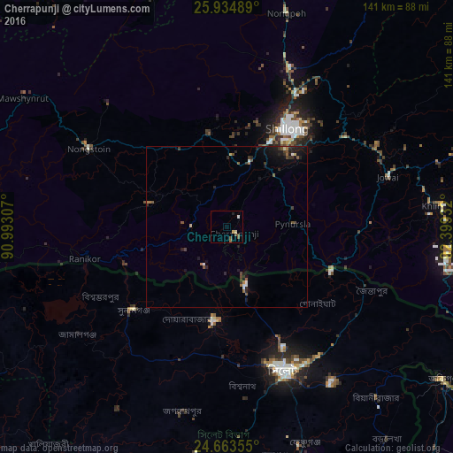
Analysis of Cherrapunji night lights 2016
Square area 10x10 km:
 0%
0%90-99
1.19%80-89
0.6%70-79
0.6%60-69
0.2%50-59
2.78%40-49
0.99%30-39
0%20-29
0.79%10-19
0%0-9
92.86%Square area 50x50 km:
0.09%90-99
0.18%80-89
0.1%70-79
0.09%60-69
0.26%50-59
0.37%40-49
0.39%30-39
0.32%20-29
0.68%10-19
1.07%0-9
96.45%Clear (daylight) street map image can be seen on geolist.org.
Map coordinates:
25° 56' 5.6" North, 90° 59' 35.1" East
25° 18' 3.2" North, 91° 41' 46.3" East
24° 39' 48.8" North, 92° 23' 57.6" East
Some cities around Cherrapunji sort by population:
• Sylhet, BD
48.1 km =29.9 mi,  158°
158°
• Shillong
35.2 km =21.9 mi,  32°
32°
• Maulavi Bāzār, BD
90.6 km =56.3 mi,  175°
175°
• Karīmganj
81.9 km =50.9 mi,  125°
125°
• Chhātak, BD
29.3 km =18.2 mi,  185°
185°
• Nongstoin
49.5 km =30.8 mi,  299°
299°
• Nongpoh
69.3 km =43.1 mi,  15°
15°
• Mairang
29.6 km =18.4 mi,  348°
348°
1274406 (p: 11,090)
Sources (retrieved 2019-11-25):
» Earth at Night: Flat Maps 2012, 2016