Ūttukkuli night lights from space
Night Light of Ūttukkuli (Tamil Nadu) from space (India) Src. Average luminocity for 10x10km area is 32.987% and for 50x50km: 29.4054%.
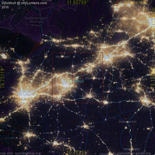
Analysis of Ūttukkuli night lights 2016
Square area 10x10 km:
 0%
0%90-99
1.52%80-89
1.08%70-79
4.98%60-69
7.79%50-59
7.58%40-49
9.74%30-39
16.45%20-29
16.45%10-19
23.38%0-9
11.04%Square area 50x50 km:
0.86%90-99
3.17%80-89
5.26%70-79
6.24%60-69
5.14%50-59
6.32%40-49
6.84%30-39
6.13%20-29
7.03%10-19
12.23%0-9
40.79%Clear (daylight) street map image can be seen on geolist.org.
Map coordinates:
11° 51' 28.4" North, 76° 45' 4.3" East
11° 10' 8.1" North, 77° 27' 15.5" East
10° 28' 41.9" North, 78° 9' 26.8" East
Some cities around Ūttukkuli sort by population:
• Tiruppur
12.4 km =7.7 mi,  241°
241°
• Palladam
26.9 km =16.7 mi,  222°
222°
• Kangayam
21.5 km =13.4 mi,  147°
147°
• Avinashi
20.4 km =12.7 mi,  277°
277°
• Perundurai
18.8 km =11.7 mi,  50°
50°
• Chennimalai
16.3 km =10.1 mi,  92°
92°
• Nambiyūr
25.6 km =15.9 mi,  325°
325°
• Vijayapuri
9.9 km =6.2 mi,  30°
30°
1253621 (p: 7,508)
Sources (retrieved 2019-11-25):
» Earth at Night: Flat Maps 2012, 2016