Vijayapuri night lights from space
Night Light of Vijayapuri (Tamil Nadu) from space (India) Src. Average luminocity for 10x10km area is 43.6883% and for 50x50km: 30.676%.
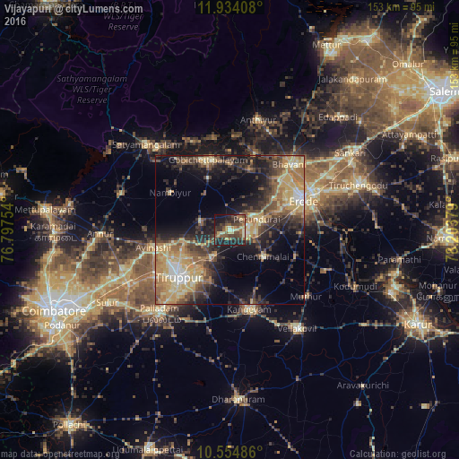
Analysis of Vijayapuri night lights 2016
Square area 10x10 km:
 0%
0%90-99
6.06%80-89
6.06%70-79
8.23%60-69
5.41%50-59
10.17%40-49
14.29%30-39
16.45%20-29
14.29%10-19
18.4%0-9
0.65%Square area 50x50 km:
1.16%90-99
3.5%80-89
6.15%70-79
6.86%60-69
4.99%50-59
4.64%40-49
6.63%30-39
6.87%20-29
7.91%10-19
12.92%0-9
38.36%Clear (daylight) street map image can be seen on geolist.org.
Map coordinates:
11° 56' 2.7" North, 76° 47' 51.1" East
11° 14' 43.1" North, 77° 30' 2.4" East
10° 33' 17.5" North, 78° 12' 13.6" East
Some cities around Vijayapuri sort by population:
• Tiruppur
21.5 km =13.4 mi,  227°
227°
• Erode
27 km =16.8 mi,  66°
66°
• Gobichettipalayam
24.2 km =15 mi,  344°
344°
• Avinashi
26 km =16.2 mi,  257°
257°
• Perundurai
10.1 km =6.3 mi, 70°
• Chennimalai
14.5 km =9 mi,  128°
128°
• Nambiyūr
23.2 km =14.4 mi,  302°
302°
• Ūttukkuli
9.9 km =6.2 mi,  210°
210°
1253186 (p: 6,651)
Sources (retrieved 2019-11-25):
» Earth at Night: Flat Maps 2012, 2016