Bhasāwar night lights from space
Night Light of Bhasāwar (Rajasthan) from space (India) Src. Average luminocity for 10x10km area is 30.4782% and for 50x50km: 20.8689%.
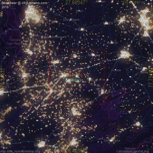
Analysis of Bhasāwar night lights 2016
Square area 10x10 km:
 0.6%
0.6%90-99
1.39%80-89
3.17%70-79
1.98%60-69
6.15%50-59
7.54%40-49
7.94%30-39
9.92%20-29
6.94%10-19
52.78%0-9
1.59%Square area 50x50 km:
0.68%90-99
1.45%80-89
2.58%70-79
2.01%60-69
3.5%50-59
3.56%40-49
4.98%30-39
4.97%20-29
9.41%10-19
20.66%0-9
46.19%Clear (daylight) street map image can be seen on geolist.org.
Map coordinates:
27° 39' 48.5" North, 76° 20' 43.3" East
27° 2' 20.2" North, 77° 2' 54.6" East
26° 24' 39.4" North, 77° 45' 5.8" East
Some cities around Bhasāwar sort by population:
• Hindaun
33.9 km =21.1 mi,  182°
182°
• Bayāna
28 km =17.4 mi,  121°
121°
• Nagar
43.1 km =26.8 mi,  6°
6°
• Nādbai
25.1 km =15.6 mi,  35°
35°
• Mahwah
11.6 km =7.2 mi,  273°
273°
• Todabhim
26.7 km =16.6 mi,  239°
239°
• Kūmher
44.4 km =27.6 mi,  45°
45°
• Wer
12.9 km =8 mi,  100°
100°
1276092 (p: 18,996)
Sources (retrieved 2019-11-25):
» Earth at Night: Flat Maps 2012, 2016