Barpathār night lights from space
Night Light of Barpathār (Assam) from space (India) Src. Average luminocity for 10x10km area is 2.8651% and for 50x50km: 2.4393%.
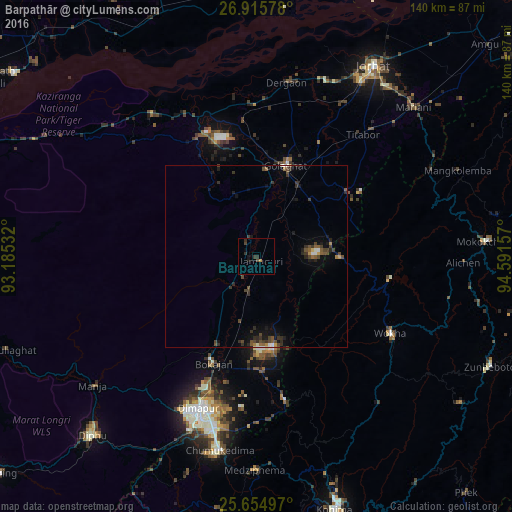
Analysis of Barpathār night lights 2016
Square area 10x10 km:
 0%
0%90-99
0%80-89
0%70-79
0.6%60-69
0.2%50-59
0%40-49
1.59%30-39
2.18%20-29
0.99%10-19
1.59%0-9
92.86%Square area 50x50 km:
0.16%90-99
0.21%80-89
0.09%70-79
0.18%60-69
0.18%50-59
0.44%40-49
0.92%30-39
0.79%20-29
0.77%10-19
1.41%0-9
94.85%Clear (daylight) street map image can be seen on geolist.org.
Map coordinates:
26° 54' 56.8" North, 93° 11' 7.2" East
26° 17' 13.5" North, 93° 53' 18.4" East
25° 39' 17.9" North, 94° 35' 29.7" East
Some cities around Barpathār sort by population:
• Dimāpur
44.9 km =27.9 mi,  201°
201°
• Wokha
42.5 km =26.4 mi,  119°
119°
• Golāghāt
26 km =16.2 mi,  15°
15°
• Bokajān
31.5 km =19.6 mi, 200°
• Dergaon
46.6 km =29 mi,  9°
9°
• Bokākhāt
48.6 km =30.2 mi,  323°
323°
• Titābar
47 km =29.2 mi,  41°
41°
• Numāligarh
40.8 km =25.4 mi,  336°
336°
1276869 (p: 7,445)
Sources (retrieved 2019-11-25):
» Earth at Night: Flat Maps 2012, 2016