Bokākhāt night lights from space
Night Light of Bokākhāt (Assam) from space (India) Src. Average luminocity for 10x10km area is 3.5587% and for 50x50km: 1.7139%.
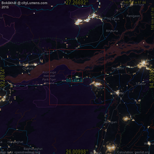
Analysis of Bokākhāt night lights 2016
Square area 10x10 km:
 0%
0%90-99
0%80-89
0.19%70-79
0.57%60-69
0%50-59
1.7%40-49
1.33%30-39
0.76%20-29
1.14%10-19
2.27%0-9
92.05%Square area 50x50 km:
0.12%90-99
0.15%80-89
0.04%70-79
0.08%60-69
0.12%50-59
0.41%40-49
0.52%30-39
0.54%20-29
0.59%10-19
1.3%0-9
96.12%Clear (daylight) street map image can be seen on geolist.org.
Map coordinates:
27° 16' 0.9" North, 92° 53' 50.6" East
26° 38' 24.6" North, 93° 36' 1.9" East
26° 0' 35.9" North, 94° 18' 13.1" East
Some cities around Bokākhāt sort by population:
• Itānagar
49.7 km =30.9 mi,  1°
1°
• Golāghāt
38.5 km =23.9 mi,  111°
111°
• Naharlagun
52.5 km =32.6 mi,  10°
10°
• Dergaon
37 km =23 mi,  79°
79°
• Bihpuriāgaon
52.4 km =32.6 mi,  36°
36°
• Gohpur
26.9 km =16.7 mi, 3°
• Barpathār
48.6 km =30.2 mi,  143°
143°
• Numāligarh
12.3 km =7.6 mi,  99°
99°
1275363 (p: 9,554)
Sources (retrieved 2019-11-25):
» Earth at Night: Flat Maps 2012, 2016