Barauli night lights from space
Night Light of Barauli (Bihar) from space (India) Src. Average luminocity for 10x10km area is 35.25% and for 50x50km: 16.2144%.
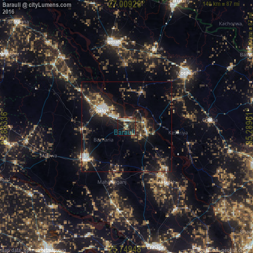
Analysis of Barauli night lights 2016
Square area 10x10 km:
 1.52%
1.52%90-99
7.01%80-89
5.11%70-79
2.65%60-69
3.41%50-59
5.87%40-49
8.71%30-39
9.09%20-29
16.67%10-19
25.95%0-9
14.02%Square area 50x50 km:
1.44%90-99
2.01%80-89
1.33%70-79
1.4%60-69
1.54%50-59
2.82%40-49
3.68%30-39
4.54%20-29
6.67%10-19
12.77%0-9
61.81%Clear (daylight) street map image can be seen on geolist.org.
Map coordinates:
27° 0' 33.3" North, 83° 53' 0.1" East
26° 22' 51.9" North, 84° 35' 11.3" East
25° 44' 58.1" North, 85° 17' 22.6" East
Some cities around Barauli sort by population:
• Bettiah
47.6 km =29.6 mi,  349°
349°
• Siwān
29.1 km =18.1 mi,  232°
232°
• Mothīhāri
44.3 km =27.5 mi,  47°
47°
• Gopālganj
17.4 km =10.8 mi,  303°
303°
• Sagauli
45.3 km =28.1 mi,  20°
20°
• Mahārājgani
31.2 km =19.4 mi,  195°
195°
• Mairwa
45.3 km =28.1 mi,  248°
248°
• Chākia
46 km =28.6 mi,  85°
85°
1277053 (p: 37,302)
Sources (retrieved 2019-11-25):
» Earth at Night: Flat Maps 2012, 2016