Bara Uchāna night lights from space
Night Light of Bara Uchāna (Haryana) from space (India) Src. Average luminocity for 10x10km area is 15.6951% and for 50x50km: 11.0759%.
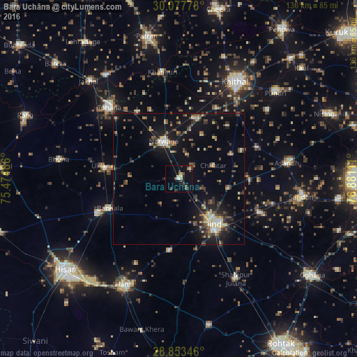
Analysis of Bara Uchāna night lights 2016
Square area 10x10 km:
 0.95%
0.95%90-99
2.27%80-89
0.57%70-79
2.46%60-69
1.33%50-59
2.84%40-49
4.55%30-39
1.89%20-29
3.98%10-19
5.3%0-9
73.86%Square area 50x50 km:
0.48%90-99
1.23%80-89
1.67%70-79
0.93%60-69
1.08%50-59
1.72%40-49
2.14%30-39
2.5%20-29
3.29%10-19
8.11%0-9
76.85%Clear (daylight) street map image can be seen on geolist.org.
Map coordinates:
30° 4' 40" North, 75° 28' 29.5" East
29° 28' 2.9" North, 76° 10' 40.7" East
28° 51' 12.5" North, 76° 52' 52" East
Some cities around Bara Uchāna sort by population:
• Jīnd
21.5 km =13.4 mi,  141°
141°
• Tohāna
38 km =23.6 mi,  315°
315°
• Narwāna
15.7 km =9.8 mi,  338°
338°
• Barwāla
28.4 km =17.6 mi,  246°
246°
• Āsandh
41.8 km =26 mi,  81°
81°
• Nārnaund
27.7 km =17.2 mi,  187°
187°
• Uklāna
29.4 km =18.3 mi,  279°
279°
• Inda Chhoi
42.1 km =26.2 mi,  297°
297°
1254000 (p: 15,830)
Sources (retrieved 2019-11-25):
» Earth at Night: Flat Maps 2012, 2016