Uklāna night lights from space
Night Light of Uklāna (Haryana) from space (India) Src. Average luminocity for 10x10km area is 17.6174% and for 50x50km: 6.6057%.
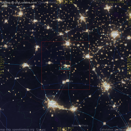
Analysis of Uklāna night lights 2016
Square area 10x10 km:
 0.38%
0.38%90-99
1.7%80-89
1.33%70-79
1.89%60-69
2.84%50-59
7.77%40-49
4.17%30-39
1.52%20-29
1.89%10-19
4.17%0-9
72.35%Square area 50x50 km:
0.46%90-99
0.9%80-89
0.76%70-79
0.43%60-69
0.88%50-59
1%40-49
1.22%30-39
1.31%20-29
1.62%10-19
4.22%0-9
87.19%Clear (daylight) street map image can be seen on geolist.org.
Map coordinates:
30° 7' 16.6" North, 75° 10' 30.4" East
29° 30' 40.5" North, 75° 52' 41.6" East
28° 53' 51" North, 76° 34' 52.9" East
Some cities around Uklāna sort by population:
• Gorakhpur
21.2 km =13.2 mi,  250°
250°
• Tohāna
22.6 km =14 mi,  6°
6°
• Narwāna
25.3 km =15.7 mi,  67°
67°
• Barwāla
16.2 km =10.1 mi,  169°
169°
• Bara Uchāna
29.4 km =18.3 mi,  99°
99°
• Jākhal
32.1 km =19.9 mi,  350°
350°
• Inda Chhoi
16.7 km =10.4 mi,  329°
329°
• Akālgarh
34.4 km =21.4 mi,  2°
2°
1253901 (p: 11,908)
Sources (retrieved 2019-11-25):
» Earth at Night: Flat Maps 2012, 2016