Āsind night lights from space
Night Light of Āsind (Rajasthan) from space (India) Src. Average luminocity for 10x10km area is 10.4716% and for 50x50km: 3.0759%.
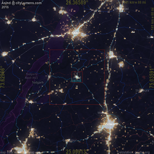
Analysis of Āsind night lights 2016
Square area 10x10 km:
 0.57%
0.57%90-99
2.84%80-89
1.89%70-79
0%60-69
0.19%50-59
1.33%40-49
2.27%30-39
1.89%20-29
2.84%10-19
1.33%0-9
84.85%Square area 50x50 km:
0.03%90-99
0.43%80-89
0.21%70-79
0.19%60-69
0.31%50-59
0.73%40-49
0.74%30-39
0.76%20-29
1%10-19
0.93%0-9
94.66%Clear (daylight) street map image can be seen on geolist.org.
Map coordinates:
26° 21' 57.2" North, 73° 37' 46.8" East
25° 44' 3.1" North, 74° 19' 58" East
25° 5' 56.9" North, 75° 2' 9.3" East
Some cities around Āsind sort by population:
• Bhīlwāra
53 km =32.9 mi,  144°
144°
• Beāwar
40.8 km =25.4 mi,  358°
358°
• Gulābpura
37.9 km =23.5 mi,  59°
59°
• Māndal
40.3 km =25 mi, 143°
• Nīmāj
56.9 km =35.4 mi,  324°
324°
• Gangāpur
57.7 km =35.9 mi,  187°
187°
• Raipur
46.2 km =28.7 mi, 317°
• Devgarh
48.5 km =30.1 mi,  241°
241°
1278278 (p: 15,389)
Sources (retrieved 2019-11-25):
» Earth at Night: Flat Maps 2012, 2016