Aroor night lights from space
Night Light of Aroor (Kerala) from space (India) Src. Average luminocity for 10x10km area is 29.8698% and for 50x50km: 15.5026%.
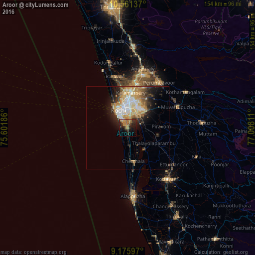

Analysis of Aroor night lights 2016
Square area 10x10 km:
 0.62%
0.62%90-99
1.65%80-89
1.24%70-79
6.82%60-69
11.16%50-59
5.58%40-49
4.13%30-39
9.92%20-29
10.12%10-19
16.53%0-9
32.23%Square area 50x50 km:
2.31%90-99
3.38%80-89
2.37%70-79
3.17%60-69
1.89%50-59
1.76%40-49
1.48%30-39
2.09%20-29
3.27%10-19
5.27%0-9
73.01%Clear (daylight) street map image can be seen on geolist.org.
Map coordinates:
10° 33' 40.9" North, 75° 36' 6.7" East
9° 52' 9.8" North, 76° 18' 17.9" East
9° 10' 33.5" North, 77° 0' 29.2" East
Some cities around Aroor sort by population:
• Cochin
9.2 km =5.7 mi,  327°
327°
• Cherthala
20.8 km =12.9 mi,  170°
170°
• Shertallai
20.8 km =12.9 mi, 169°
• Vayalār
17.9 km =11.1 mi, 168°
• Kumbalam
4.2 km =2.6 mi,  9°
9°
• Kutiatodu
8.3 km =5.2 mi,  158°
158°
• Vaikam
16.8 km =10.4 mi,  143°
143°
• Arukutti
4.9 km =3 mi,  93°
93°
10628607 (p: 39,214)
Sources (retrieved 2019-11-25):
» Earth at Night: Flat Maps 2012, 2016