Ālampur night lights from space
Night Light of Ālampur (Telangana) from space (India) Src. Average luminocity for 10x10km area is 12.0152% and for 50x50km: 11.6347%.
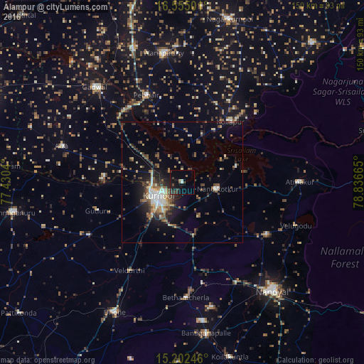
Analysis of Ālampur night lights 2016
Square area 10x10 km:
 0.22%
0.22%90-99
1.52%80-89
0%70-79
0.87%60-69
0.87%50-59
0.65%40-49
2.38%30-39
6.28%20-29
3.46%10-19
15.15%0-9
68.61%Square area 50x50 km:
0.74%90-99
1.92%80-89
1.14%70-79
0.77%60-69
1.79%50-59
2.11%40-49
2.05%30-39
2.82%20-29
3.33%10-19
6.31%0-9
77.03%Clear (daylight) street map image can be seen on geolist.org.
Map coordinates:
16° 33' 18" North, 77° 25' 49.4" East
15° 52' 47.5" North, 78° 8' 0.7" East
15° 12' 8.9" North, 78° 50' 11.9" East
Some cities around Ālampur sort by population:
• Kurnool
11.9 km =7.4 mi,  241°
241°
• Nandyāl
58.3 km =36.2 mi,  140°
140°
• Gadwāl
53.5 km =33.2 mi,  317°
317°
• Wanparti
54.6 km =33.9 mi,  352°
352°
• Nandikotkūr
14.4 km =8.9 mi,  100°
100°
• Dhone
60.8 km =37.8 mi,  207°
207°
• Betamcherla
47.7 km =29.6 mi,  178°
178°
• Atmakūr
48.5 km =30.1 mi,  89°
89°
1279074 (p: 14,060)
Sources (retrieved 2019-11-25):
» Earth at Night: Flat Maps 2012, 2016