Aduthurai night lights from space
Night Light of Aduthurai (Tamil Nadu) from space (India) Src. Average luminocity for 10x10km area is 13.0303% and for 50x50km: 9.4003%.
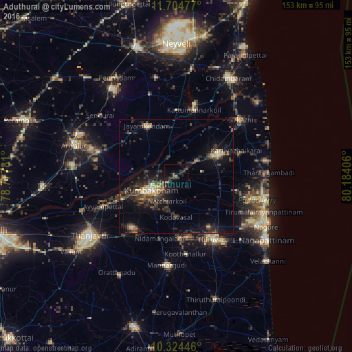
Analysis of Aduthurai night lights 2016
Square area 10x10 km:
 0%
0%90-99
0%80-89
0%70-79
1.52%60-69
1.95%50-59
0.87%40-49
6.49%30-39
5.63%20-29
6.28%10-19
9.96%0-9
67.32%Square area 50x50 km:
0.17%90-99
0.69%80-89
0.78%70-79
1.33%60-69
0.54%50-59
1.18%40-49
2.83%30-39
3.45%20-29
4.6%10-19
7.25%0-9
77.19%Clear (daylight) street map image can be seen on geolist.org.
Map coordinates:
11° 42' 17.2" North, 78° 46' 40.1" East
11° 0' 55.5" North, 79° 28' 51.3" East
10° 19' 28.1" North, 80° 11' 2.6" East
Some cities around Aduthurai sort by population:
• Kumbakonam
11.4 km =7.1 mi,  238°
238°
• Mayiladuthurai
21.4 km =13.3 mi,  62°
62°
• Jayamkondacholapuram
25.4 km =15.8 mi,  329°
329°
• Papanasam
25 km =15.5 mi,  246°
246°
• Thiruvidaimaruthur
3.6 km =2.2 mi, 239°
• Valangaiman
16.9 km =10.5 mi,  214°
214°
• Nannilam
20.7 km =12.9 mi,  136°
136°
• Swāmimalai
17.8 km =11.1 mi, 248°
1279318 (p: 11,433)
Sources (retrieved 2019-11-25):
» Earth at Night: Flat Maps 2012, 2016