Kefar Weradim night lights from space
Night Light of Kefar Weradim (Northern District) from space (Israel) Src. Average luminocity for 10x10km area is 66.7711% and for 50x50km: 49.4339%.
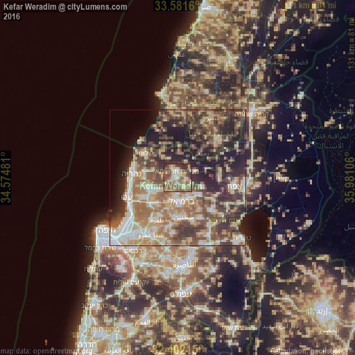
Analysis of Kefar Weradim night lights 2016
Square area 10x10 km:
 6.96%
6.96%90-99
10.62%80-89
16.48%70-79
12.82%60-69
7.69%50-59
21.25%40-49
13.19%30-39
8.24%20-29
2.75%10-19
0%0-9
0%Square area 50x50 km:
6.39%90-99
6.64%80-89
10.44%70-79
7.19%60-69
8.1%50-59
8.1%40-49
10.66%30-39
10.27%20-29
11.37%10-19
10.97%0-9
9.87%Clear (daylight) street map image can be seen on geolist.org.
Map coordinates:
33° 34' 53.8" North, 34° 34' 29.3" East
32° 59' 37.9" North, 35° 16' 40.5" East
32° 24' 7.7" North, 35° 58' 51.8" East
Some cities around Kefar Weradim sort by population:
• Karmi’el
8.9 km =5.5 mi,  163°
163°
• maalot Tarshīhā
2.7 km =1.7 mi,  337°
337°
• Judeida Makr
13.4 km =8.3 mi,  237°
237°
• Naḥf
7.5 km =4.7 mi,  151°
151°
• Beit Jann
10.2 km =6.3 mi,  108°
108°
• Kfar Yasif
11.6 km =7.2 mi,  247°
247°
• Ḥurfeish
7.1 km =4.4 mi,  68°
68°
• Buqei‘a
5.5 km =3.4 mi, 109°
386445 (p: 5,608)
Sources (retrieved 2019-11-25):
» Earth at Night: Flat Maps 2012, 2016