Beit Jann night lights from space
Night Light of Beit Jann (Northern District) from space (Israel) Src. Average luminocity for 10x10km area is 46.1337% and for 50x50km: 49.1138%.
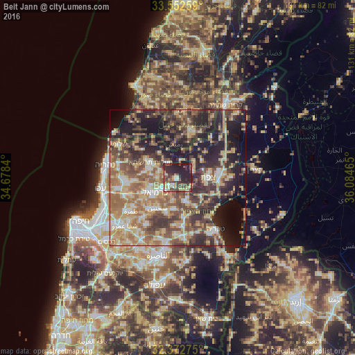
Analysis of Beit Jann night lights 2016
Square area 10x10 km:
 3.48%
3.48%90-99
5.31%80-89
9.52%70-79
6.23%60-69
2.2%50-59
7.69%40-49
15.57%30-39
10.62%20-29
29.67%10-19
9.71%0-9
0%Square area 50x50 km:
4.36%90-99
5.72%80-89
11.73%70-79
7.53%60-69
8.56%50-59
8.16%40-49
10.64%30-39
10.29%20-29
12.97%10-19
14.27%0-9
5.78%Clear (daylight) street map image can be seen on geolist.org.
Map coordinates:
33° 33' 9.3" North, 34° 40' 42.2" East
32° 57' 52.7" North, 35° 22' 53.5" East
32° 22' 21.9" North, 36° 5' 4.7" East
Some cities around Beit Jann sort by population:
• Karmi’el
8.9 km =5.5 mi,  233°
233°
• Safed
10.7 km =6.6 mi,  89°
89°
• Maghār
8.7 km =5.4 mi,  164°
164°
• Naḥf
6.9 km =4.3 mi,  240°
240°
• Deir Ḥannā
11.5 km =7.1 mi,  188°
188°
• Kefar Weradim
10.2 km =6.3 mi,  288°
288°
• Ḥurfeish
6.6 km =4.1 mi,  332°
332°
• Buqei‘a
4.7 km =2.9 mi, 287°
295523 (p: 10,002)
Sources (retrieved 2019-11-25):
» Earth at Night: Flat Maps 2012, 2016