Ḥurfeish night lights from space
Night Light of Ḥurfeish (Northern District) from space (Israel) Src. Average luminocity for 10x10km area is 39.8425% and for 50x50km: 49.8854%.
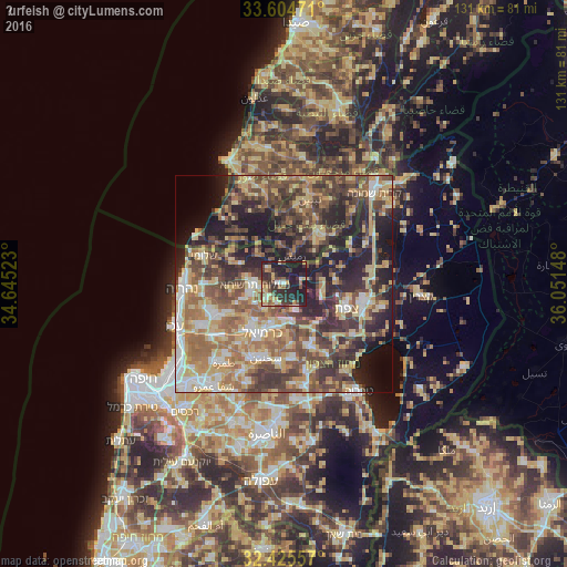
Analysis of Ḥurfeish night lights 2016
Square area 10x10 km:
 2.01%
2.01%90-99
3.66%80-89
6.96%70-79
6.78%60-69
3.85%50-59
4.95%40-49
7.33%30-39
15.02%20-29
23.08%10-19
26.37%0-9
0%Square area 50x50 km:
5.01%90-99
5.98%80-89
11.51%70-79
7.51%60-69
8.37%50-59
7.92%40-49
12.01%30-39
10.86%20-29
12.57%10-19
12.29%0-9
5.97%Clear (daylight) street map image can be seen on geolist.org.
Map coordinates:
33° 36' 17" North, 34° 38' 42.8" East
33° 1' 1.6" North, 35° 20' 54.1" East
32° 25' 32.1" North, 36° 3' 5.3" East
Some cities around Ḥurfeish sort by population:
• Karmi’el
11.8 km =7.3 mi,  199°
199°
• Safed
15 km =9.3 mi,  112°
112°
• maalot Tarshīhā
7.6 km =4.7 mi,  269°
269°
• Maghār
15.2 km =9.4 mi,  158°
158°
• Naḥf
9.7 km =6 mi, 197°
• Beit Jann
6.6 km =4.1 mi,  152°
152°
• Kefar Weradim
7.1 km =4.4 mi,  248°
248°
• Buqei‘a
4.6 km =2.9 mi, 197°
294666 (p: 5,308)
Sources (retrieved 2019-11-25):
» Earth at Night: Flat Maps 2012, 2016