Marino night lights from space
Night Light of Marino (Leinster) from space (Ireland) Src. Average luminocity for 10x10km area is 93.4074% and for 50x50km: 23.1698%.
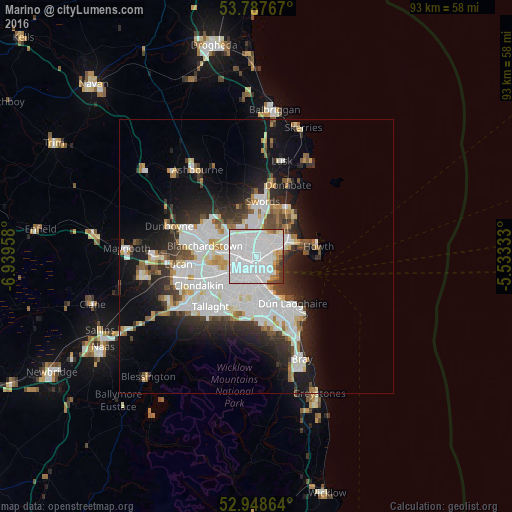
Analysis of Marino night lights 2016
Square area 10x10 km:
100  68.92%
90-99 15.74%
80-89 2.38%
70-79 3.31%
60-69 1.85%
50-59 2.51%
40-49 1.32%
30-39 3.97%
20-29 0%
10-19 0%
0-9 0%
68.92%90-99
15.74%80-89
2.38%70-79
3.31%60-69
1.85%50-59
2.51%40-49
1.32%30-39
3.97%20-29
0%10-19
0%0-9
0%Square area 50x50 km:
100 8.16%
90-99 5.28%
80-89 1.65%
70-79 1.63%
60-69 1.66%
50-59 1.5%
40-49 2.1%
30-39 2.63%
20-29 5.17%
10-19 9.67%
0-9 60.54%
8.16%90-99
5.28%80-89
1.65%70-79
1.63%60-69
1.66%50-59
1.5%40-49
2.1%30-39
2.63%20-29
5.17%10-19
9.67%0-9
60.54%Clear (daylight) street map image can be seen on geolist.org.
Map coordinates:
53° 47' 15.6" North, 6° 56' 22.5" West
53° 22' 12.8" North, 6° 14' 11.3" West
52° 56' 55.1" North, 5° 31' 60" West
Some cities around Marino sort by population:
• Beaumont
2 km =1.2 mi,  18°
18°
• Ringsend
3.2 km =2 mi,  168°
168°
• Donnycarney
1.8 km =1.1 mi,  78°
78°
• Raheny
4.1 km =2.5 mi,  63°
63°
• Ballymun
3.7 km =2.3 mi,  326°
326°
• Artane
2.4 km =1.5 mi,  38°
38°
• Killester
2.2 km =1.4 mi, 81°
• Dollymount
3.8 km =2.4 mi,  99°
99°
2962696 (p: 11,023)
Sources (retrieved 2019-11-25):
» Earth at Night: Flat Maps 2012, 2016