Lembar night lights from space
Night Light of Lembar (West Nusa Tenggara) from space (Indonesia) Src. Average luminocity for 10x10km area is 20.469% and for 50x50km: 13.7974%.
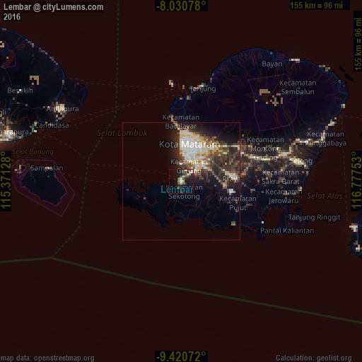
Analysis of Lembar night lights 2016
Square area 10x10 km:
 0.62%
0.62%90-99
4.55%80-89
1.45%70-79
2.48%60-69
0.21%50-59
3.51%40-49
4.55%30-39
6.61%20-29
5.17%10-19
20.04%0-9
50.83%Square area 50x50 km:
1.17%90-99
3.43%80-89
2.15%70-79
1.3%60-69
0.93%50-59
1.78%40-49
3.01%30-39
3.37%20-29
4.61%10-19
6.62%0-9
71.62%Clear (daylight) street map image can be seen on geolist.org.
Map coordinates:
8° 1' 50.8" South, 115° 22' 16.6" East
8° 43' 35" South, 116° 4' 27.8" East
9° 25' 14.6" South, 116° 46' 39.1" East
Some cities around Lembar sort by population:
• Mataram
16.6 km =10.3 mi,  16°
16°
• Praya
21.7 km =13.5 mi,  83°
83°
• Amlapura city
60 km =37.3 mi,  300°
300°
• Amlapura
59 km =36.7 mi, 301°
• Ubud
92.1 km =57.2 mi,  285°
285°
• Klungkung
77.2 km =48 mi, 286°
• Bedugul
61.2 km =38 mi, 300°
• Labuan Lombok
69.8 km =43.4 mi,  68°
68°
1638059 (p: 10,000)
Sources (retrieved 2019-11-25):
» Earth at Night: Flat Maps 2012, 2016