Veresegyház night lights from space
Night Light of Veresegyház (Pest) from space (Hungary) Src. Average luminocity for 10x10km area is 28.9464% and for 50x50km: 23.0592%.
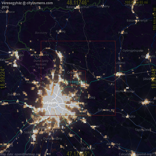
Analysis of Veresegyház night lights 2016
Square area 10x10 km:
 2.83%
2.83%90-99
4.32%80-89
2.08%70-79
3.42%60-69
3.27%50-59
5.51%40-49
4.91%30-39
6.55%20-29
5.06%10-19
41.22%0-9
20.83%Square area 50x50 km:
8.94%90-99
4.24%80-89
1.62%70-79
1.53%60-69
1.98%50-59
2.41%40-49
2.31%30-39
3.12%20-29
3.63%10-19
9.14%0-9
61.09%Clear (daylight) street map image can be seen on geolist.org.
Map coordinates:
48° 7' 2.9" North, 18° 35' 32.1" East
47° 38' 45.2" North, 19° 17' 43.3" East
47° 10' 12.2" North, 19° 59' 54.6" East
Some cities around Veresegyház sort by population:
• Gödöllő
7.1 km =4.4 mi,  140°
140°
• Dunakeszi
11.8 km =7.3 mi,  264°
264°
• Fót
8.6 km =5.3 mi,  248°
248°
• Kistarcsa
11.2 km =7 mi,  192°
192°
• Kerepes
9.6 km =6 mi, 185°
• Csömör
11.6 km =7.2 mi,  203°
203°
• Erdőkertes
3.1 km =1.9 mi,  17°
17°
• Őrbottyán
4.7 km =2.9 mi,  348°
348°
3042968 (p: 11,087)
Sources (retrieved 2019-11-25):
» Earth at Night: Flat Maps 2012, 2016