Kistarcsa night lights from space
Night Light of Kistarcsa (Pest) from space (Hungary) Src. Average luminocity for 10x10km area is 37.4474% and for 50x50km: 29.7836%.
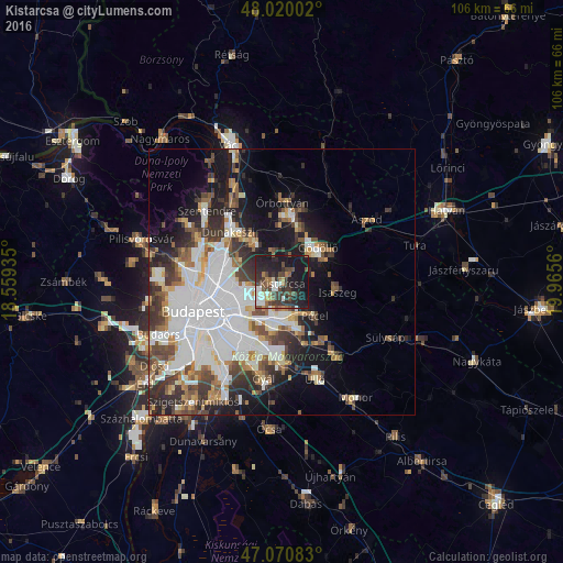
Analysis of Kistarcsa night lights 2016
Square area 10x10 km:
 5.54%
5.54%90-99
5.11%80-89
2.13%70-79
1.7%60-69
4.69%50-59
5.68%40-49
9.52%30-39
13.07%20-29
15.2%10-19
37.07%0-9
0.28%Square area 50x50 km:
10.04%90-99
5.56%80-89
2.22%70-79
2.29%60-69
2.97%50-59
3.4%40-49
3.89%30-39
4.84%20-29
5.59%10-19
10.93%0-9
48.27%Clear (daylight) street map image can be seen on geolist.org.
Map coordinates:
48° 1' 12.1" North, 18° 33' 33.7" East
47° 32' 51.3" North, 19° 15' 44.9" East
47° 4' 15" North, 19° 57' 56.2" East
Some cities around Kistarcsa sort by population:
• Budapest XVII. kerület
7.5 km =4.7 mi,  184°
184°
• Budapest XVI. kerület
7.8 km =4.8 mi,  242°
242°
• Gödöllő
8.8 km =5.5 mi,  51°
51°
• Fót
9.6 km =6 mi,  324°
324°
• Pécel
8.8 km =5.5 mi,  137°
137°
• Isaszeg
10.7 km =6.6 mi,  100°
100°
• Kerepes
2.1 km =1.3 mi, 47°
• Csömör
2.2 km =1.4 mi,  277°
277°
3050290 (p: 10,986)
Sources (retrieved 2019-11-25):
» Earth at Night: Flat Maps 2012, 2016