Kerepes night lights from space
Night Light of Kerepes (Pest) from space (Hungary) Src. Average luminocity for 10x10km area is 31.8707% and for 50x50km: 28.6898%.
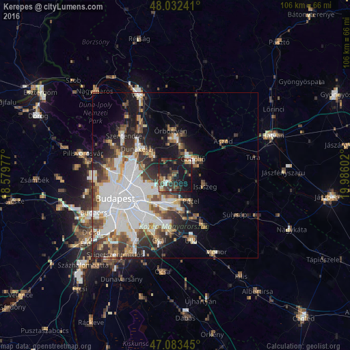
Analysis of Kerepes night lights 2016
Square area 10x10 km:
 2.56%
2.56%90-99
3.27%80-89
2.84%70-79
2.56%60-69
4.55%50-59
4.69%40-49
8.52%30-39
8.66%20-29
10.94%10-19
46.02%0-9
5.4%Square area 50x50 km:
10.02%90-99
5.41%80-89
2.1%70-79
2.22%60-69
2.87%50-59
3.16%40-49
3.47%30-39
4.35%20-29
5.02%10-19
10.59%0-9
50.8%Clear (daylight) street map image can be seen on geolist.org.
Map coordinates:
48° 1' 56.7" North, 18° 34' 47.2" East
47° 33' 36.3" North, 19° 16' 58.4" East
47° 5' 0.4" North, 19° 59' 9.7" East
Some cities around Kerepes sort by population:
• Budapest XVII. kerület
9.2 km =5.7 mi,  193°
193°
• Gödöllő
6.8 km =4.2 mi,  53°
53°
• Fót
9.5 km =5.9 mi,  312°
312°
• Pécel
9 km =5.6 mi,  150°
150°
• Veresegyház
9.6 km =6 mi,  5°
5°
• Kistarcsa
2.1 km =1.3 mi,  227°
227°
• Isaszeg
9.5 km =5.9 mi,  110°
110°
• Csömör
3.9 km =2.4 mi,  253°
253°
7284912 (p: 9,960)
Sources (retrieved 2019-11-25):
» Earth at Night: Flat Maps 2012, 2016