Săcueni night lights from space
Night Light of Săcueni (Bihor) from space (Romania) Src. Average luminocity for 10x10km area is 1.2455% and for 50x50km: 0.733%.
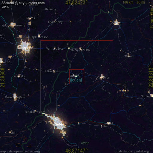
Analysis of Săcueni night lights 2016
Square area 10x10 km:
 0%
0%90-99
0%80-89
0.6%70-79
0%60-69
0.3%50-59
0.3%40-49
0.6%30-39
0%20-29
0%10-19
0.6%0-9
97.62%Square area 50x50 km:
0.04%90-99
0.07%80-89
0.05%70-79
0.06%60-69
0.07%50-59
0.08%40-49
0.13%30-39
0.14%20-29
0.31%10-19
0.83%0-9
98.22%Clear (daylight) street map image can be seen on geolist.org.
Map coordinates:
47° 49' 27.2" North, 21° 23' 48.8" East
47° 21' 0" North, 22° 6' 0" East
46° 52' 17.3" North, 22° 48' 11.3" East
Some cities around Săcueni sort by population:
• Marghita
17.6 km =10.9 mi,  90°
90°
• Valea lui Mihai
18.9 km =11.7 mi,  11°
11°
• Popeşti
27.2 km =16.9 mi,  118°
118°
• Létavértes, HU
15.5 km =9.6 mi,  283°
283°
• Tileagd
32.4 km =20.1 mi,  166°
166°
• Diosig
9.4 km =5.8 mi,  233°
233°
• Hosszúpályi, HU
28.1 km =17.5 mi, 279°
• Vámospércs, HU
25.3 km =15.7 mi,  323°
323°
668297 (p: 7,075)
Sources (retrieved 2019-11-25):
» Earth at Night: Flat Maps 2012, 2016