Bátonyterenye night lights from space
Night Light of Bátonyterenye (Nógrád) from space (Hungary) Src. Average luminocity for 10x10km area is 3.3011% and for 50x50km: 1.7965%.
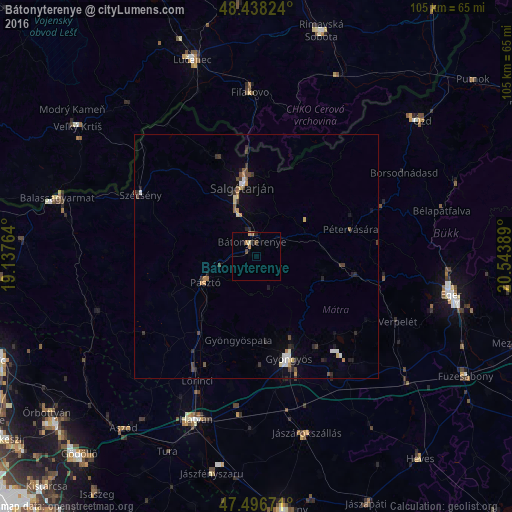
Analysis of Bátonyterenye night lights 2016
Square area 10x10 km:
 0%
0%90-99
0.28%80-89
0.28%70-79
1.14%60-69
1.14%50-59
0%40-49
1.14%30-39
0%20-29
0.43%10-19
1.28%0-9
94.32%Square area 50x50 km:
0.16%90-99
0.22%80-89
0.16%70-79
0.31%60-69
0.15%50-59
0.21%40-49
0.37%30-39
0.33%20-29
0.49%10-19
0.46%0-9
97.14%Clear (daylight) street map image can be seen on geolist.org.
Map coordinates:
48° 26' 17.7" North, 19° 8' 15.5" East
47° 58' 10.6" North, 19° 50' 26.7" East
47° 29' 48.2" North, 20° 32' 38" East
Some cities around Bátonyterenye sort by population:
• Parádsasvár
12 km =7.5 mi,  121°
121°
• Salgótarján
14.6 km =9.1 mi,  348°
348°
• Gyöngyös
21.8 km =13.5 mi,  162°
162°
• Hatvan
35.7 km =22.2 mi,  199°
199°
• Fiľakovo, SK
33.2 km =20.6 mi,  357°
357°
• Pásztó
12 km =7.5 mi,  242°
242°
• Szécsény
26.8 km =16.7 mi,  297°
297°
• Lőrinci
29 km =18 mi, 204°
3055287 (p: 14,214)
Sources (retrieved 2019-11-25):
» Earth at Night: Flat Maps 2012, 2016