Putnok night lights from space
Night Light of Putnok (Borsod-Abaúj-Zemplén) from space (Hungary) Src. Average luminocity for 10x10km area is 0.7128% and for 50x50km: 1.7787%.
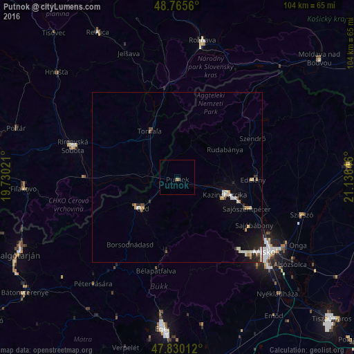
Analysis of Putnok night lights 2016
Square area 10x10 km:
 0%
0%90-99
0%80-89
0%70-79
0%60-69
0.6%50-59
0%40-49
0.6%30-39
0%20-29
0%10-19
0%0-9
98.81%Square area 50x50 km:
0.24%90-99
0.41%80-89
0.14%70-79
0.24%60-69
0.16%50-59
0.12%40-49
0.16%30-39
0.14%20-29
0.42%10-19
1.04%0-9
96.93%Clear (daylight) street map image can be seen on geolist.org.
Map coordinates:
48° 45' 56.2" North, 19° 43' 48.8" East
48° 18' 0" North, 20° 25' 60" East
47° 49' 48.4" North, 21° 8' 11.3" East
Some cities around Putnok sort by population:
• Miskolc
34.2 km =21.3 mi,  130°
130°
• Ózd
13.5 km =8.4 mi,  226°
226°
• Kazincbarcika
15.8 km =9.8 mi,  110°
110°
• Rimavská Sobota, SK
31.7 km =19.7 mi,  286°
286°
• Sajószentpéter
22.9 km =14.2 mi, 113°
• Edelény
22.2 km =13.8 mi,  90°
90°
• Felsőzsolca
39.1 km =24.3 mi,  124°
124°
• Szikszó
38.7 km =24 mi, 106°
716247 (p: 7,501)
Sources (retrieved 2019-11-25):
» Earth at Night: Flat Maps 2012, 2016