Nyergesújfalu night lights from space
Night Light of Nyergesújfalu (Komárom-Esztergom) from space (Hungary) Src. Average luminocity for 10x10km area is 5.753% and for 50x50km: 4.5325%.
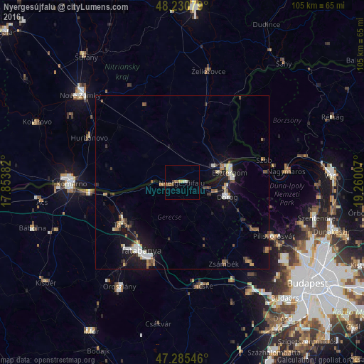
Analysis of Nyergesújfalu night lights 2016
Square area 10x10 km:
 0.6%
0.6%90-99
0.6%80-89
0%70-79
1.19%60-69
1.04%50-59
2.38%40-49
0.6%30-39
0.45%20-29
0.6%10-19
0%0-9
92.56%Square area 50x50 km:
0.5%90-99
0.77%80-89
0.35%70-79
0.41%60-69
0.61%50-59
0.84%40-49
0.45%30-39
0.55%20-29
0.68%10-19
4.45%0-9
90.39%Clear (daylight) street map image can be seen on geolist.org.
Map coordinates:
48° 13' 50.8" North, 17° 51' 13.8" East
47° 45' 37" North, 18° 33' 25" East
47° 17' 7.7" North, 19° 15' 36.3" East
Some cities around Nyergesújfalu sort by population:
• Tatabánya
23 km =14.3 mi,  212°
212°
• Esztergom
14.3 km =8.9 mi,  75°
75°
• Tata
21.5 km =13.4 mi,  236°
236°
• Dorog
14.1 km =8.8 mi,  108°
108°
• Štúrovo, SK
12.6 km =7.8 mi,  72°
72°
• Piliscsaba
24.7 km =15.3 mi,  124°
124°
• Tát
7.1 km =4.4 mi, 107°
• Lábatlan
4.8 km =3 mi,  252°
252°
3047282 (p: 7,667)
Sources (retrieved 2019-11-25):
» Earth at Night: Flat Maps 2012, 2016