Piliscsaba night lights from space
Night Light of Piliscsaba (Pest) from space (Hungary) Src. Average luminocity for 10x10km area is 5.2158% and for 50x50km: 21.1123%.
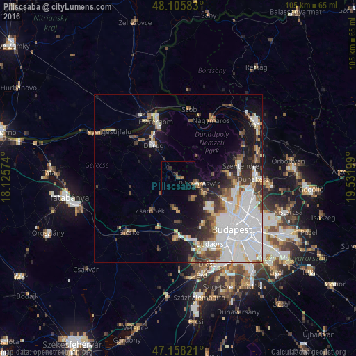
Analysis of Piliscsaba night lights 2016
Square area 10x10 km:
100  0%
0%
90-99 0%
80-89 0%
70-79 0%
60-69 1.04%
50-59 2.53%
40-49 1.04%
30-39 0.15%
20-29 2.68%
10-19 2.68%
0-9 89.88%
0%90-99
0%80-89
0%70-79
0%60-69
1.04%50-59
2.53%40-49
1.04%30-39
0.15%20-29
2.68%10-19
2.68%0-9
89.88%Square area 50x50 km:
100 8.22%
90-99 3.88%
80-89 1.56%
70-79 1.37%
60-69 1.91%
50-59 2.06%
40-49 2.07%
30-39 2.66%
20-29 2.76%
10-19 7.73%
0-9 65.78%
8.22%90-99
3.88%80-89
1.56%70-79
1.37%60-69
1.91%50-59
2.06%40-49
2.07%30-39
2.66%20-29
2.76%10-19
7.73%0-9
65.78%Clear (daylight) street map image can be seen on geolist.org.
Map coordinates:
48° 6' 21" North, 18° 7' 32.7" East
47° 38' 3" North, 18° 49' 43.9" East
47° 9' 29.6" North, 19° 31' 55.2" East
Some cities around Piliscsaba sort by population:
• Esztergom
18.8 km =11.7 mi,  339°
339°
• Pomáz
14.9 km =9.3 mi,  86°
86°
• Budakeszi
15.6 km =9.7 mi,  151°
151°
• Dorog
11.9 km =7.4 mi,  324°
324°
• Solymár
9 km =5.6 mi,  120°
120°
• Biatorbágy
18.2 km =11.3 mi,  182°
182°
• Tát
18 km =11.2 mi,  311°
311°
• Páty
13 km =8.1 mi, 180°
3046353 (p: 6,468)
Sources (retrieved 2019-11-25):
» Earth at Night: Flat Maps 2012, 2016