Marcali night lights from space
Night Light of Marcali (Somogy) from space (Hungary) Src. Average luminocity for 10x10km area is 5.0043% and for 50x50km: 1.8566%.
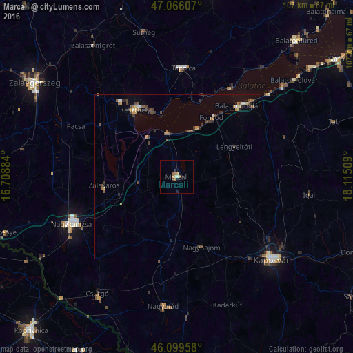
Analysis of Marcali night lights 2016
Square area 10x10 km:
 0%
0%90-99
1.14%80-89
0.57%70-79
0.28%60-69
1.99%50-59
0.57%40-49
0.57%30-39
0.57%20-29
1.14%10-19
0.85%0-9
92.33%Square area 50x50 km:
0.11%90-99
0.18%80-89
0.16%70-79
0.14%60-69
0.32%50-59
0.45%40-49
0.57%30-39
0.4%20-29
0.39%10-19
0.22%0-9
97.07%Clear (daylight) street map image can be seen on geolist.org.
Map coordinates:
47° 3' 57.9" North, 16° 42' 31.8" East
46° 35' 5.9" North, 17° 24' 43.1" East
46° 5' 58.5" North, 18° 6' 54.3" East
Some cities around Marcali sort by population:
• Kaposvár
38.4 km =23.9 mi,  129°
129°
• Nagykanizsa
35.4 km =22 mi,  245°
245°
• Keszthely
24.1 km =15 mi,  327°
327°
• Tapolca
33 km =20.5 mi,  3°
3°
• Nagyatád
39.7 km =24.7 mi,  185°
185°
• Balatonboglár
27.6 km =17.1 mi,  39°
39°
• Csurgó
43.9 km =27.3 mi,  212°
212°
• Fonyód
22.9 km =14.2 mi,  33°
33°
3048456 (p: 12,344)
Sources (retrieved 2019-11-25):
» Earth at Night: Flat Maps 2012, 2016