Tököl night lights from space
Night Light of Tököl (Pest) from space (Hungary) Src. Average luminocity for 10x10km area is 35.2872% and for 50x50km: 24.0569%.
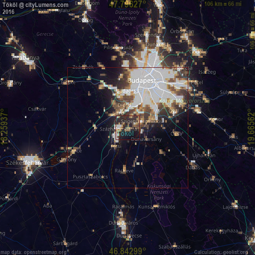
Analysis of Tököl night lights 2016
Square area 10x10 km:
 3.72%
3.72%90-99
3.87%80-89
2.53%70-79
3.87%60-69
4.61%50-59
7.89%40-49
5.95%30-39
6.99%20-29
26.49%10-19
24.7%0-9
9.38%Square area 50x50 km:
8.82%90-99
4.43%80-89
1.56%70-79
2.12%60-69
2.13%50-59
2.6%40-49
3.43%30-39
3.25%20-29
3.92%10-19
6.58%0-9
61.16%Clear (daylight) street map image can be seen on geolist.org.
Map coordinates:
47° 47' 46.6" North, 18° 15' 33.7" East
47° 19' 18.4" North, 18° 57' 45" East
46° 50' 34.8" North, 19° 39' 56.2" East
Some cities around Tököl sort by population:
• Érd
8.9 km =5.5 mi,  335°
335°
• Szigetszentmiklós
6.6 km =4.1 mi,  68°
68°
• Százhalombatta
2 km =1.2 mi,  295°
295°
• Szigethalom
3 km =1.9 mi,  88°
88°
• Ercsi
9.2 km =5.7 mi,  212°
212°
• Halásztelek
4.7 km =2.9 mi,  17°
17°
• Taksony
7.9 km =4.9 mi,  83°
83°
• Dunavarsány
9.2 km =5.7 mi,  121°
121°
3043860 (p: 10,164)
Sources (retrieved 2019-11-25):
» Earth at Night: Flat Maps 2012, 2016