Berhida night lights from space
Night Light of Berhida (Veszprém) from space (Hungary) Src. Average luminocity for 10x10km area is 5.0227% and for 50x50km: 6.0753%.
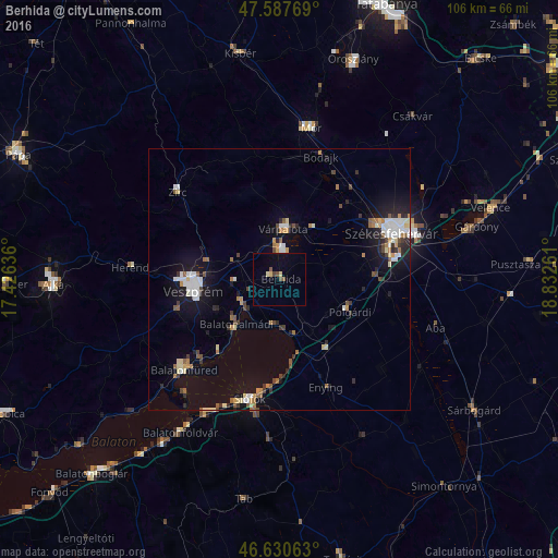
Analysis of Berhida night lights 2016
Square area 10x10 km:
 0%
0%90-99
0%80-89
1.7%70-79
0%60-69
0%50-59
1.56%40-49
1.28%30-39
0%20-29
0%10-19
0.85%0-9
94.6%Square area 50x50 km:
0.87%90-99
1.05%80-89
0.66%70-79
0.49%60-69
0.74%50-59
0.72%40-49
0.69%30-39
0.64%20-29
1.22%10-19
4.11%0-9
88.8%Clear (daylight) street map image can be seen on geolist.org.
Map coordinates:
47° 35' 15.7" North, 17° 25' 34.9" East
47° 6' 40.7" North, 18° 7' 46.1" East
46° 37' 50.3" North, 18° 49' 57.4" East
Some cities around Berhida sort by population:
• Székesfehérvár
23 km =14.3 mi,  67°
67°
• Veszprém
16.6 km =10.3 mi,  263°
263°
• Siófok
23.7 km =14.7 mi,  193°
193°
• Várpalota
9.8 km =6.1 mi,  4°
4°
• Balatonfüred
25.6 km =15.9 mi,  229°
229°
• Balatonalmádi
11.8 km =7.3 mi,  224°
224°
• Enying
21.8 km =13.5 mi,  157°
157°
• Polgárdi
14.2 km =8.8 mi,  113°
113°
3055091 (p: 5,822)
Sources (retrieved 2019-11-25):
» Earth at Night: Flat Maps 2012, 2016