San Lorenzo night lights from space
Night Light of San Lorenzo (Valle) from space (Honduras) Src. Average luminocity for 10x10km area is 12.6364% and for 50x50km: 1.3583%.
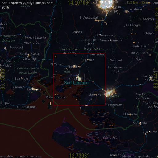

Analysis of San Lorenzo night lights 2016
Square area 10x10 km:
 0%
0%90-99
0.83%80-89
1.86%70-79
2.07%60-69
2.89%50-59
2.07%40-49
4.34%30-39
2.48%20-29
2.48%10-19
1.65%0-9
79.34%Square area 50x50 km:
0%90-99
0.03%80-89
0.09%70-79
0.18%60-69
0.31%50-59
0.13%40-49
0.58%30-39
0.44%20-29
0.26%10-19
0.66%0-9
97.3%Clear (daylight) street map image can be seen on geolist.org.
Map coordinates:
14° 6' 25.5" North, 88° 9' 1.3" West
13° 25' 27" North, 87° 26' 50" West
12° 44' 21.5" North, 86° 44' 38.8" West
Some cities around San Lorenzo sort by population:
• Ciudad Choluteca
31 km =19.3 mi,  116°
116°
• La Unión, SV
44 km =27.3 mi,  257°
257°
• Nacaome
13.2 km =8.2 mi,  340°
340°
• Santa Rosa de Lima, SV
53.2 km =33.1 mi,  294°
294°
• El Triunfo
59.3 km =36.8 mi,  125°
125°
• La Alianza
31.5 km =19.6 mi, 288°
• Monjarás
26.1 km =16.2 mi,  162°
162°
• San Alejo, SV
55.8 km =34.7 mi,  270°
270°
3601977 (p: 22,289)
Sources (retrieved 2019-11-25):
» Earth at Night: Flat Maps 2012, 2016