Monjarás night lights from space
Night Light of Monjarás (Choluteca) from space (Honduras) Src. Average luminocity for 10x10km area is 2.1818% and for 50x50km: 2.187%.
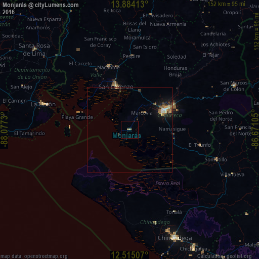
Analysis of Monjarás night lights 2016
Square area 10x10 km:
 0%
0%90-99
0%80-89
0.87%70-79
0.65%60-69
0.22%50-59
0%40-49
0.87%30-39
0%20-29
0%10-19
0.43%0-9
96.97%Square area 50x50 km:
0.14%90-99
0.23%80-89
0.3%70-79
0.22%60-69
0.48%50-59
0.34%40-49
0.42%30-39
0.41%20-29
0.39%10-19
1.82%0-9
95.26%Clear (daylight) street map image can be seen on geolist.org.
Map coordinates:
13° 53' 2.9" North, 88° 4' 38.3" West
13° 12' 2" North, 87° 22' 27" West
12° 30' 54.3" North, 86° 40' 15.8" West
Some cities around Monjarás sort by population:
• Ciudad Choluteca
22.7 km =14.1 mi,  60°
60°
• La Unión, SV
53 km =32.9 mi,  286°
286°
• San Lorenzo
26.1 km =16.2 mi,  342°
342°
• Somotillo, NI
53.7 km =33.4 mi,  108°
108°
• Nacaome
39.3 km =24.4 mi, 341°
• Puerto Morazán, NI
44.7 km =27.8 mi,  150°
150°
• El Triunfo
41.6 km =25.8 mi,  102°
102°
• La Alianza
51.3 km =31.9 mi,  312°
312°
3604686 (p: 6,772)
Sources (retrieved 2019-11-25):
» Earth at Night: Flat Maps 2012, 2016