Ajuterique night lights from space
Night Light of Ajuterique (Comayagua) from space (Honduras) Src. Average luminocity for 10x10km area is 6.4719% and for 50x50km: 4.4714%.
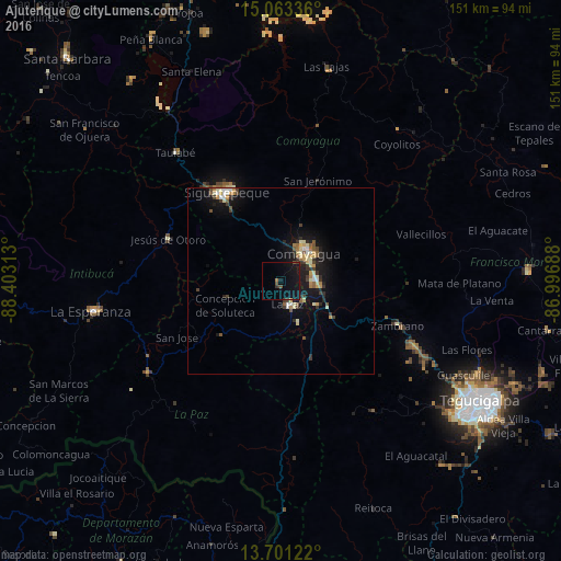
Analysis of Ajuterique night lights 2016
Square area 10x10 km:
 0%
0%90-99
0%80-89
0%70-79
0%60-69
0.87%50-59
0%40-49
2.16%30-39
1.3%20-29
0%10-19
14.72%0-9
80.95%Square area 50x50 km:
0.3%90-99
0.63%80-89
0.65%70-79
0.63%60-69
0.39%50-59
0.57%40-49
0.63%30-39
0.87%20-29
0.85%10-19
4.39%0-9
90.09%Clear (daylight) street map image can be seen on geolist.org.
Map coordinates:
15° 3' 48.1" North, 88° 24' 11.3" West
14° 22' 60" North, 87° 42' 0" West
13° 42' 4.4" North, 86° 59' 48.8" West
Some cities around Ajuterique sort by population:
• Comayagua
10.1 km =6.3 mi,  41°
41°
• Siguatepeque
28 km =17.4 mi,  329°
329°
• La Paz
7.4 km =4.6 mi,  162°
162°
• Intibucá
50.8 km =31.6 mi,  261°
261°
• Marcala
44.3 km =27.5 mi,  234°
234°
• Jesús de Otoro
32.5 km =20.2 mi,  290°
290°
• Villa de San Antonio
11.6 km =7.2 mi,  129°
129°
• La Esperanza
52.4 km =32.6 mi, 261°
3615279 (p: 5,354)
Sources (retrieved 2019-11-25):
» Earth at Night: Flat Maps 2012, 2016