Marcala night lights from space
Night Light of Marcala (La Paz) from space (Honduras) Src. Average luminocity for 10x10km area is 3.1623% and for 50x50km: 0.6282%.
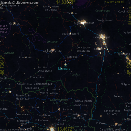
Analysis of Marcala night lights 2016
Square area 10x10 km:
 0%
0%90-99
0.87%80-89
0%70-79
0.87%60-69
0%50-59
0.87%40-49
0.87%30-39
1.73%20-29
0%10-19
0%0-9
94.81%Square area 50x50 km:
0.04%90-99
0.06%80-89
0%70-79
0.09%60-69
0.11%50-59
0.23%40-49
0.18%30-39
0.13%20-29
0.13%10-19
0.05%0-9
98.98%Clear (daylight) street map image can be seen on geolist.org.
Map coordinates:
14° 49' 50.7" North, 88° 44' 11.3" West
14° 9' 0" North, 88° 1' 60" West
13° 28' 1.9" North, 87° 19' 48.8" West
Some cities around Marcala sort by population:
• La Paz
42.6 km =26.5 mi,  63°
63°
• San Francisco, SV
50.5 km =31.4 mi,  188°
188°
• Intibucá
23.5 km =14.6 mi,  322°
322°
• Ciudad Barrios, SV
49.5 km =30.8 mi,  210°
210°
• Jesús de Otoro
37.5 km =23.3 mi,  8°
8°
• Villa de San Antonio
48.6 km =30.2 mi,  67°
67°
• Ajuterique
44.3 km =27.5 mi,  54°
54°
• La Esperanza
23.9 km =14.9 mi, 318°
3605005 (p: 10,054)
Sources (retrieved 2019-11-25):
» Earth at Night: Flat Maps 2012, 2016