Santa Lucía Milpas Altas night lights from space
Night Light of Santa Lucía Milpas Altas (Sacatepéquez) from space (Guatemala) Src. Average luminocity for 10x10km area is 39.5411% and for 50x50km: 29.6971%.
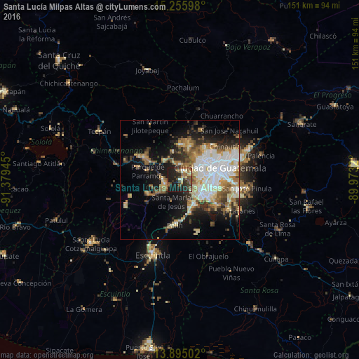
Analysis of Santa Lucía Milpas Altas night lights 2016
Square area 10x10 km:
 0.87%
0.87%90-99
4.33%80-89
6.28%70-79
3.9%60-69
8.01%50-59
8.87%40-49
7.79%30-39
8.44%20-29
20.13%10-19
31.39%0-9
0%Square area 50x50 km:
6.08%90-99
6.35%80-89
3.86%70-79
3.34%60-69
4.62%50-59
3.3%40-49
3.37%30-39
3.57%20-29
4.94%10-19
13.25%0-9
47.31%Clear (daylight) street map image can be seen on geolist.org.
Map coordinates:
15° 15' 21.5" North, 91° 22' 46" West
14° 34' 35.6" North, 90° 40' 34.8" West
13° 53' 42.1" North, 89° 58' 23.5" West
Some cities around Santa Lucía Milpas Altas sort by population:
• Mixco
9.6 km =6 mi,  51°
51°
• Antigua Guatemala
6.5 km =4 mi,  254°
254°
• Santiago Sacatepéquez
6.5 km =4 mi,  359°
359°
• San Lucas Sacatepéquez
4.3 km =2.7 mi,  28°
28°
• Jocotenango
6.6 km =4.1 mi,  271°
271°
• Pastores
8.7 km =5.4 mi,  283°
283°
• San Bartolomé Milpas Altas
3.4 km =2.1 mi, 356°
• Magdalena Milpas Altas
3.2 km =2 mi,  176°
176°
3589285 (p: 13,001)
Sources (retrieved 2019-11-25):
» Earth at Night: Flat Maps 2012, 2016