Pastores night lights from space
Night Light of Pastores (Sacatepéquez) from space (Guatemala) Src. Average luminocity for 10x10km area is 24.5325% and for 50x50km: 21.9062%.
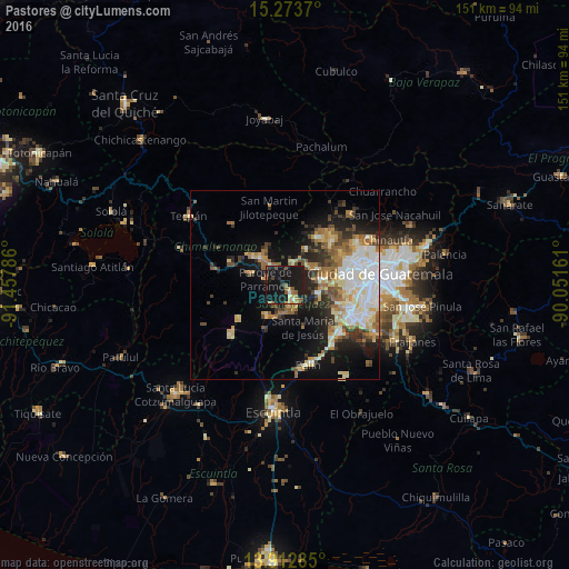
Analysis of Pastores night lights 2016
Square area 10x10 km:
 0%
0%90-99
2.6%80-89
1.08%70-79
4.11%60-69
5.63%50-59
4.76%40-49
1.95%30-39
1.08%20-29
3.68%10-19
67.32%0-9
7.79%Square area 50x50 km:
3.91%90-99
4.31%80-89
3.09%70-79
2.39%60-69
3.43%50-59
2.62%40-49
2.57%30-39
2.79%20-29
4.11%10-19
11.91%0-9
58.87%Clear (daylight) street map image can be seen on geolist.org.
Map coordinates:
15° 16' 25.3" North, 91° 27' 28.3" West
14° 35' 39.6" North, 90° 45' 17" West
13° 54' 46.3" North, 90° 3' 5.8" West
Some cities around Pastores sort by population:
• Antigua Guatemala
4.3 km =2.7 mi,  149°
149°
• Ciudad Vieja
7.9 km =4.9 mi,  186°
186°
• Sumpango
6.2 km =3.9 mi,  20°
20°
• Jocotenango
2.5 km =1.6 mi,  135°
135°
• El Tejar
7 km =4.3 mi,  326°
326°
• Parramos
5.4 km =3.4 mi,  287°
287°
• San Antonio Aguas Calientes
6 km =3.7 mi,  207°
207°
• San Bartolomé Milpas Altas
8.4 km =5.2 mi,  80°
80°
3591574 (p: 10,393)
Sources (retrieved 2019-11-25):
» Earth at Night: Flat Maps 2012, 2016