San Bartolomé Milpas Altas night lights from space
Night Light of San Bartolomé Milpas Altas (Sacatepéquez) from space (Guatemala) Src. Average luminocity for 10x10km area is 46.4654% and for 50x50km: 29.3683%.
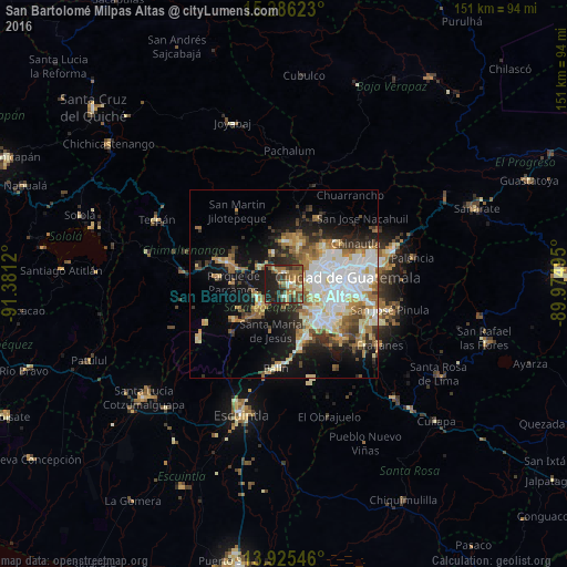
Analysis of San Bartolomé Milpas Altas night lights 2016
Square area 10x10 km:
 1.3%
1.3%90-99
4.76%80-89
6.93%70-79
4.98%60-69
14.5%50-59
12.12%40-49
11.47%30-39
9.09%20-29
15.15%10-19
19.7%0-9
0%Square area 50x50 km:
6.08%90-99
6.27%80-89
3.8%70-79
3.32%60-69
4.62%50-59
3.27%40-49
3.37%30-39
3.57%20-29
4.94%10-19
13.16%0-9
47.6%Clear (daylight) street map image can be seen on geolist.org.
Map coordinates:
15° 17' 10.4" North, 91° 22' 52.3" West
14° 36' 24.8" North, 90° 40' 41.1" West
13° 55' 31.7" North, 89° 58' 29.8" West
Some cities around San Bartolomé Milpas Altas sort by population:
• Mixco
8.1 km =5 mi,  70°
70°
• Antigua Guatemala
7.9 km =4.9 mi,  229°
229°
• Santiago Sacatepéquez
3.1 km =1.9 mi,  3°
3°
• Sumpango
7.5 km =4.7 mi,  305°
305°
• San Lucas Sacatepéquez
2.3 km =1.4 mi,  79°
79°
• Jocotenango
7.2 km =4.5 mi,  243°
243°
• Santa Lucía Milpas Altas
3.4 km =2.1 mi,  176°
176°
• Magdalena Milpas Altas
6.6 km =4.1 mi, 176°
3590393 (p: 6,261)
Sources (retrieved 2019-11-25):
» Earth at Night: Flat Maps 2012, 2016