San Miguel Chicaj night lights from space
Night Light of San Miguel Chicaj (Baja Verapaz) from space (Guatemala) Src. Average luminocity for 10x10km area is 0.6529% and for 50x50km: 0.3492%.
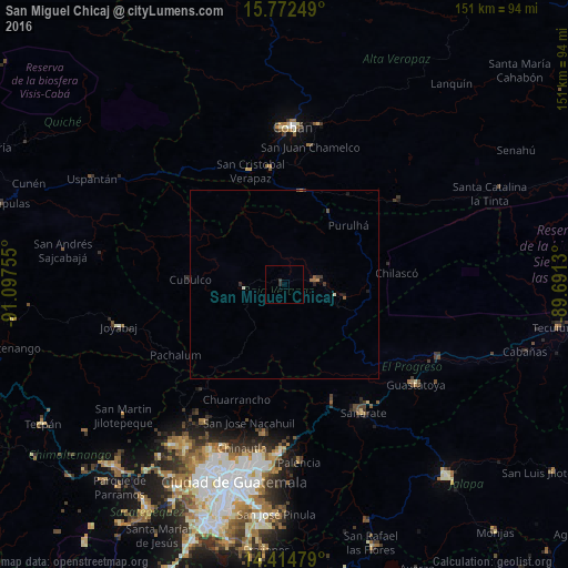
Analysis of San Miguel Chicaj night lights 2016
Square area 10x10 km:
 0%
0%90-99
0%80-89
0%70-79
0%60-69
0%50-59
0%40-49
0%30-39
0.83%20-29
0.83%10-19
0%0-9
98.35%Square area 50x50 km:
0%90-99
0.03%80-89
0.03%70-79
0.02%60-69
0.1%50-59
0.07%40-49
0.06%30-39
0.13%20-29
0.12%10-19
0.17%0-9
99.26%Clear (daylight) street map image can be seen on geolist.org.
Map coordinates:
15° 46' 21" North, 91° 5' 51.2" West
15° 5' 41" North, 90° 23' 39.9" West
14° 24' 53.2" North, 89° 41' 28.7" West
Some cities around San Miguel Chicaj sort by population:
• Salamá
8.2 km =5.1 mi,  83°
83°
• Rabinal
10.6 km =6.6 mi,  264°
264°
• Cubulco
25.2 km =15.7 mi,  272°
272°
• Tactic
25.7 km =16 mi,  9°
9°
• San Jerónimo
17 km =10.6 mi,  103°
103°
• Chuarrancho
33.4 km =20.8 mi,  202°
202°
• Santa Cruz Verapaz
30.5 km =19 mi,  352°
352°
• Purulhá
28.3 km =17.6 mi,  47°
47°
3589730 (p: 13,747)
Sources (retrieved 2019-11-25):
» Earth at Night: Flat Maps 2012, 2016