Purulhá night lights from space
Night Light of Purulhá (Baja Verapaz) from space (Guatemala) Src. Average luminocity for 10x10km area is 0.1715% and for 50x50km: 1.3398%.
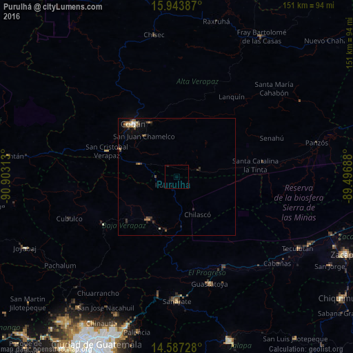
Analysis of Purulhá night lights 2016
Square area 10x10 km:
 0%
0%90-99
0%80-89
0%70-79
0%60-69
0%50-59
0%40-49
0%30-39
0%20-29
0.41%10-19
0.41%0-9
99.17%Square area 50x50 km:
0.08%90-99
0.16%80-89
0.1%70-79
0.13%60-69
0.42%50-59
0.22%40-49
0.12%30-39
0.46%20-29
0.14%10-19
0.54%0-9
97.63%Clear (daylight) street map image can be seen on geolist.org.
Map coordinates:
15° 56' 37.9" North, 90° 54' 11.3" West
15° 16' 0" North, 90° 12' 0" West
14° 35' 14.2" North, 89° 29' 48.8" West
Some cities around Purulhá sort by population:
• Cobán
29.2 km =18.1 mi,  321°
321°
• Salamá
22.2 km =13.8 mi,  214°
214°
• San Miguel Chicaj
28.3 km =17.6 mi,  227°
227°
• San Pedro Carchá
25.1 km =15.6 mi,  343°
343°
• San Juan Chamelco
23.4 km =14.5 mi, 322°
• Tactic
17.7 km =11 mi,  290°
290°
• San Jerónimo
23.4 km =14.5 mi,  190°
190°
• Santa Cruz Verapaz
27.4 km =17 mi, 293°
3591028 (p: 5,370)
Sources (retrieved 2019-11-25):
» Earth at Night: Flat Maps 2012, 2016