La Libertad night lights from space
Night Light of La Libertad (Petén) from space (Guatemala) Src. Average luminocity for 10x10km area is 7.7316% and for 50x50km: 1.3119%.
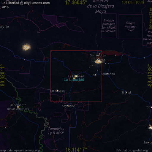
Analysis of La Libertad night lights 2016
Square area 10x10 km:
 0%
0%90-99
0.65%80-89
1.08%70-79
2.6%60-69
1.3%50-59
0.43%40-49
2.38%30-39
1.95%20-29
1.3%10-19
0.65%0-9
87.66%Square area 50x50 km:
0.03%90-99
0.18%80-89
0.12%70-79
0.53%60-69
0.05%50-59
0.03%40-49
0.27%30-39
0.29%20-29
0.27%10-19
0.5%0-9
97.73%Clear (daylight) street map image can be seen on geolist.org.
Map coordinates:
17° 27' 37.6" North, 90° 49' 12.4" West
16° 47' 18.6" North, 90° 7' 1.1" West
16° 6' 51" North, 89° 24' 49.9" West
Some cities around La Libertad sort by population:
• San Benito
25.4 km =15.8 mi,  55°
55°
• Flores
27.5 km =17.1 mi, 57°
• Dolores
80.7 km =50.1 mi,  112°
112°
• Santa Ana
30.2 km =18.8 mi,  87°
87°
• Sayaxché
30.3 km =18.8 mi,  194°
194°
• Benemérito de las Américas, MX
64.7 km =40.2 mi,  242°
242°
• San Andrés
29.1 km =18.1 mi,  47°
47°
• Frontera Corozal, MX
81.6 km =50.7 mi,  272°
272°
3594422 (p: 8,646)
Sources (retrieved 2019-11-25):
» Earth at Night: Flat Maps 2012, 2016