El Progreso night lights from space
Night Light of El Progreso (Jutiapa) from space (Guatemala) Src. Average luminocity for 10x10km area is 12.0931% and for 50x50km: 1.7291%.
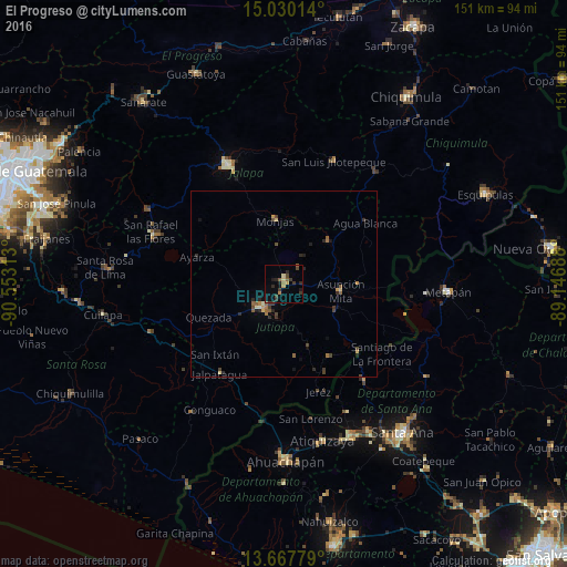
Analysis of El Progreso night lights 2016
Square area 10x10 km:
 0%
0%90-99
0%80-89
1.95%70-79
1.52%60-69
2.16%50-59
1.73%40-49
2.81%30-39
4.11%20-29
4.33%10-19
3.03%0-9
78.35%Square area 50x50 km:
0%90-99
0.08%80-89
0.25%70-79
0.23%60-69
0.24%50-59
0.41%40-49
0.44%30-39
0.44%20-29
0.63%10-19
0.38%0-9
96.9%Clear (daylight) street map image can be seen on geolist.org.
Map coordinates:
15° 1' 48.5" North, 90° 33' 11.3" West
14° 21' 0" North, 89° 51' 0" West
13° 40' 4" North, 89° 8' 48.8" West
Some cities around El Progreso sort by population:
• Jutiapa
8.2 km =5.1 mi,  217°
217°
• Asunción Mita
15.1 km =9.4 mi,  98°
98°
• Atescatempa
22.7 km =14.1 mi,  149°
149°
• Santa Catarina Mita
15.5 km =9.6 mi,  44°
44°
• Jalpatagua
28.8 km =17.9 mi, 216°
• Monjas
16.8 km =10.4 mi,  353°
353°
• San José Acatempa
31.3 km =19.4 mi,  252°
252°
• Candelaria de La Frontera, SV
33.7 km =20.9 mi,  140°
140°
3596423 (p: 7,350)
Sources (retrieved 2019-11-25):
» Earth at Night: Flat Maps 2012, 2016